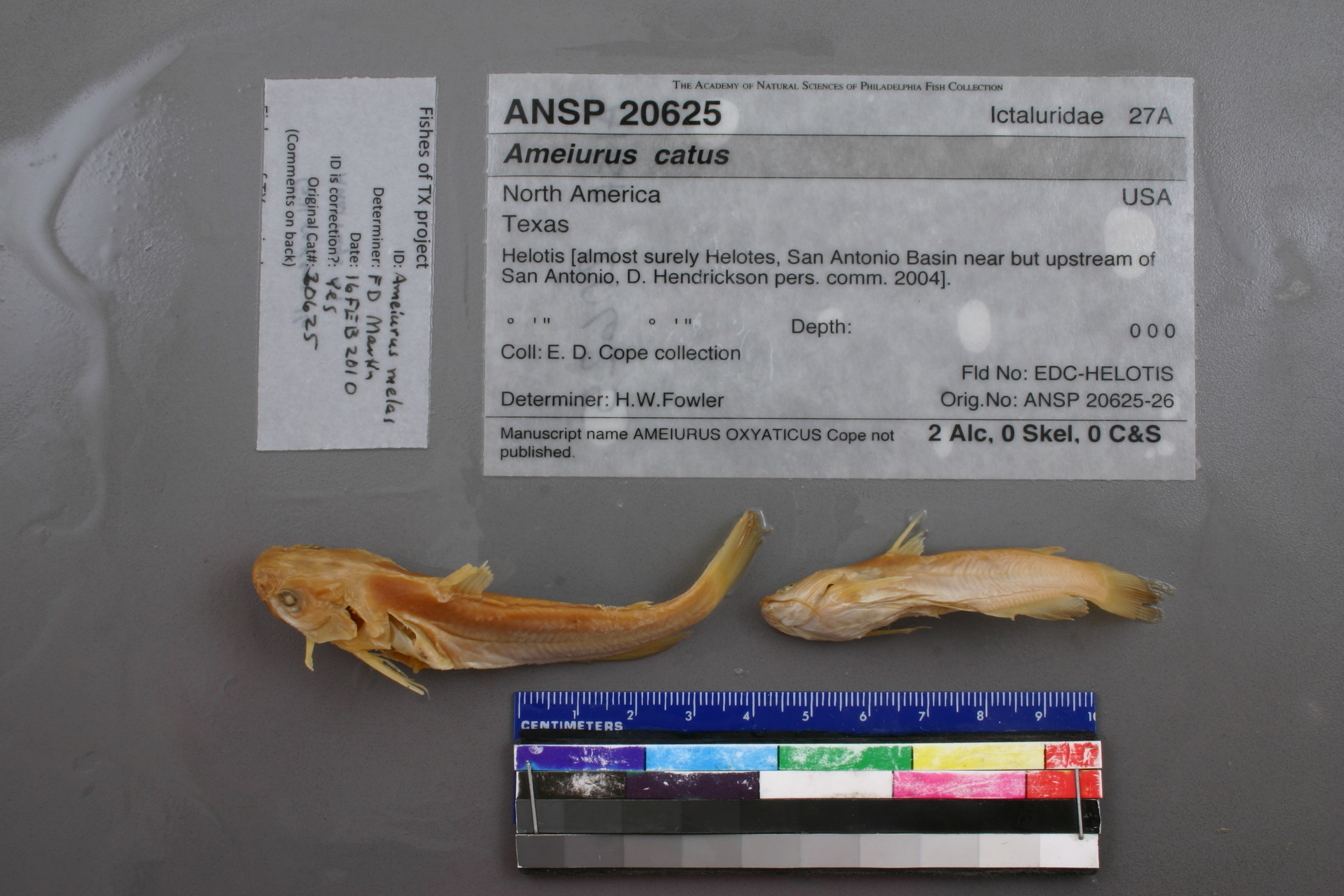
ANSP_20625
Not suspect, examinedPhotos
Map
Location
29.57784° N, 98.68924° W
(± 2266.0
m)
Taxonomy
GenusAmeiurus
Speciescatus
Identification
DeterminerH.W.Fowler
Collection Event
CollectorE.D.Cope collection
Collected Datenone
Geography
CountryUnknown
StateUnknown
CountyUnknown
LocalityHelotis.
Record Source
Source
Academy of Natural Sciences
(type: specimens)
Institution
Academy of Natural Sciences
(type: museum)
Curator
John G. Lundberg (but transitioning out)
Record Added
May 13, 2010
Record Last Modified
July 27, 2022
Data Processing Track
Track 2
From Data Set Received
04/2009 to 10/2010
Identification
Suspect Notes
None
Count
No data
Current Determination
Determiner
Floyd Douglas Martin
Determination Date
Feb. 16, 2010
Determination Type
specimen examination
Identification Comments
ID complete | Gill rakers 16, anal rays 21
Identification Confidence
High
Collecting Event
Collected
Jan. 1, 1877
– Dec. 31, 1877
Collector(s)
Collecting Event ID
7574
Collecting Event Notes This map represents Cope's Texas trips (see map: https://bioone.org/journals/transactions-of-the-kansas-academy-of-science/volume-119/issue-3-4/062.119.0409/The-Last-Time--Edward-Drinker-Copes-Last-Trip-to/10.1660/062.119.0409.full?tab=ArticleLinkFigureTable). He was in TX on at least 1892/93 and 1877 and 1874. His Rio Grande and NM collections are from 1874 (based o this map and records from the RG with 1874 date).
Field Notes
There are no field notes available.
Locality
Region
Edwards Plateau
Jurisdiction
Bexar, Texas
Name
Helotes
Hydrography
Texas-Gulf Region
Central Texas Coastal
San Antonio
Medina
Leon Creek
Lower Culebra Creek
Captive
no
Locality Photos
No locality photos available.
flag (suspect/examine)
suspect: FALSE
date
note: This map represents Cope's Texas trips (see map: https://bioone.org/journals/transactions-of-the-kansas-academy-of-science/volume-119/issue-3-4/062.119.0409/The-Last-Time--Edward-Drinker-Copes-Last-Trip-to/10.1660/062.119.0409.full?tab=ArticleLinkFigureTable). He was in TX on at least 1892/93 and 1877 and 1874. His Rio Grande and NM collections are from 1874 (based o this map and records from the RG with 1874 date).
date_range: 1/1/1877-12/31/1877
flag (suspect/examine)
suspect: noexamination: yes
date
date_range: 5/1/1877-11/30/1892
collectors
collectors: Cope, Edward Drinker
collectors
collectors: E.D. Cope
date
date_range: 5/1/1877-11/31/1892
staff comment
ID Status: Specimen examined and ID'ed for FoTX projectID Comments: Gill rakers 16, anal rays 21
Georef Remark: Updated coordinates because original georeference was incorrect. Lat and Long were same number.
ID Confidence: highGeoref Annotation: Helotes not Helotis
georeference
Error: 2265.95635199028
Remarks: Updated coordinates because original georeference was incorrect. Lat and Long were same number. Helotes not Helotis
Locality: HelotesCoordinates: 29.577838285;-98.689243009Georeferencer: MJCGeographic note: Inland USA TexasUpdated coordinates because original georeference was incorrect. Lat and Long were same number. Helotes not Helotis
Comments On ANSP_20625