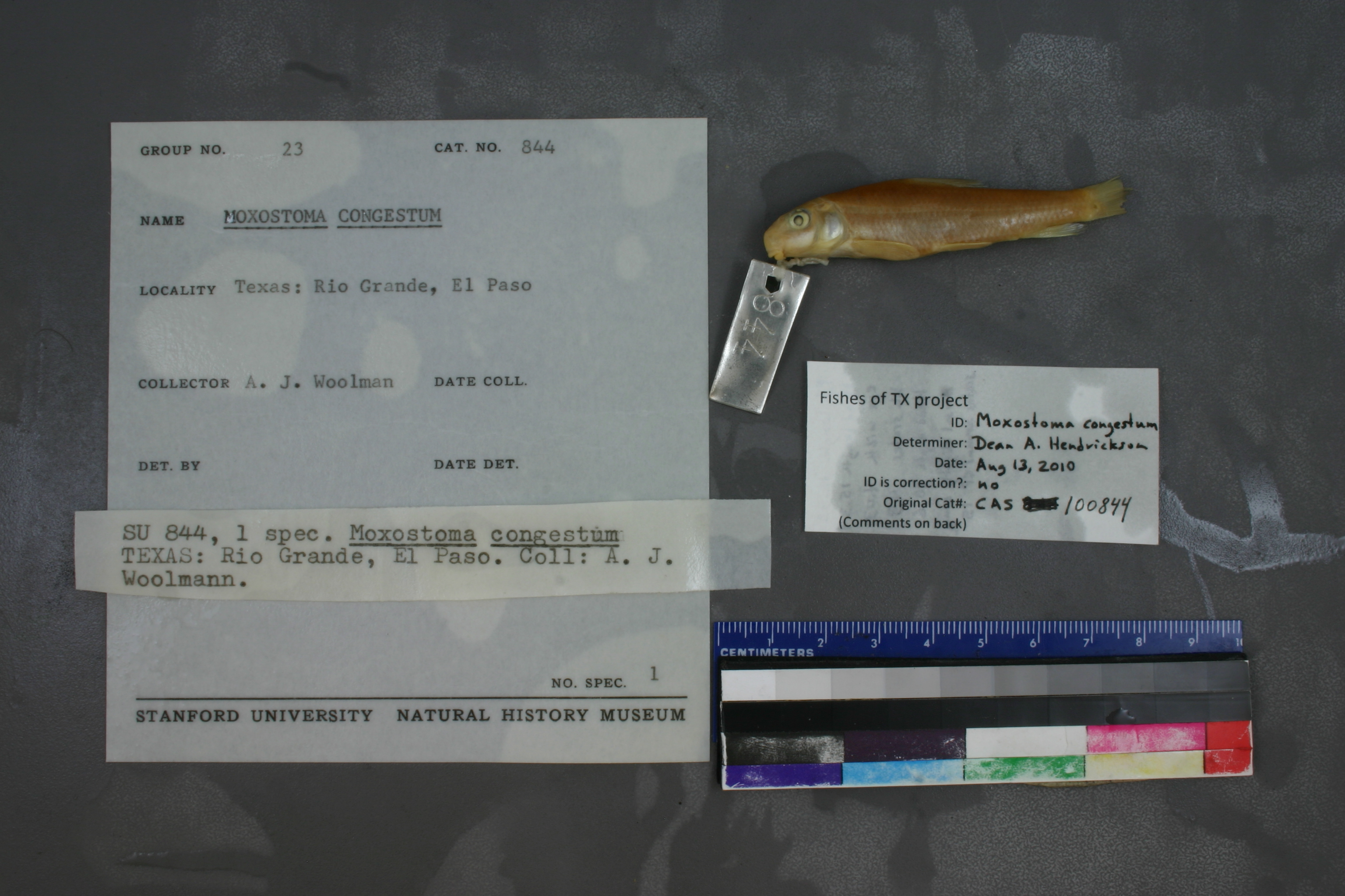
CAS_100844
Not suspect, examinedPhotos
Map
Location
31.75227° N, 106.49504° W
(± 4700
m)
Taxonomy
GenusMoxostoma
Speciescongestum
Specimen
Num Specimens0
Identification
DeterminerA. J. WOOLMAN 1894
Collection Event
CollectorALBERT J. WOOLMAN & ULYSSES O. COX
Collected Datenone
Geography
DrainageRio Grande
CountryUnited States
StateTexas
CountyEl Paso
Localityabove the waterworks at El Paso del Norte
Record Source
Source
California Academy of Sciences
(type: specimens)
Institution
California Academy of Sciences
(type: museum)
Curator
Luiz Rocha
Record Added
May 13, 2010
Record Last Modified
July 27, 2022
Data Processing Track
Track 2
From Data Set Received
04/2009 to 10/2010
Identification
Suspect Notes
None
Count
No data
Current Determination
Determiner
Dean Hendrickson
Determination Date
Aug. 13, 2010
Determination Type
specimen examination
Identification Comments
ID complete | P1 length=12.88; head length=15.34; eye width=4.03; LL scales=43; head depth=10.6; dorsal slightly concave; scales around cp= 15
Identification Confidence
High
Collecting Event
Collected
Jan. 1, 1891
– Dec. 31, 1891
Collector(s)
Collecting Event ID
7677
Field Notes
There are no field notes available.
Locality
Region
Trans Pecos
Jurisdiction
El Paso, Texas
Name
Rio Grande at El Paso
Hydrography
Rio Grande Region
Rio Grande-Amistad
Rio Grande-Fort Quitman
Rio Grande-Fort Quitman
Bowman Lateral-Rio Grande
McKelligon Canyon
Captive
no
Locality Photos
No locality photos available.
HUC 12
130401000103
Georeferencing Remarks
Woolman's report (https://www.biodiversitylibrary.org/item/215790#page/73/mode/1up) indicates that he collected on the Rio Grande at the water works in El Paso. Can't find location of historic water pump station, but point placed on river at current water treatment plant, which falls inthe the historical geography of El Paso, based on a 1908 map (http://legacy.lib.utexas.edu/maps/historical/el_paso08.jpg). Extent runs to edge of town as indicated on the map.
Georeferencing Annotation
—
Has not been Georeferenced because
—
flag (suspect/examine)
suspect: FALSE
flag (suspect/examine)
suspect: noexamination: yes
georeference
Error: 4700
Remarks: Woolman's report (https://www.biodiversitylibrary.org/item/215790#page/73/mode/1up) indicates that he collected on the Rio Grande at the water works in El Paso. Can't find location of historic water pump station, but point placed on river at current water treatment plant, which falls inthe the historical geography of El Paso, based on a 1908 map (http://legacy.lib.utexas.edu/maps/historical/el_paso08.jpg). Extent runs to edge of town as indicated on the map.
Locality: Rio Grande at El PasoCoordinates: -106.495044, 31.752268Georeferencer: Adam CohenWoolman's report (https://www.biodiversitylibrary.org/item/215790#page/73/mode/1up) indicates that he collected on the Rio Grande at the water works in El Paso. Can't find location of historic water pump station, but point placed on river at current water treatment plant, which falls inthe the historical geography of El Paso, based on a 1908 map (http://legacy.lib.utexas.edu/maps/historical/el_paso08.jpg). Extent runs to edge of town as indicated on the map.
date
date_range: 1/1/1891-12/31/1891
collectors
collectors: Woolman, Albert J. Cox, Ullyses O.
staff comment
ID Status: Specimen examined and ID'ed for FoTX project
ID Comments: P1 length=12.88; head length=15.34; eye width=4.03; LL scales=43; head depth=10.6; dorsal slightly concave; scales around cp= 15
Georef Remark: Treated as shown. Extent runs halfway to Fabens.ID Confidence: high
collectors
collectors: Albert J. Woolman, Ullyses O. Cox
date
date_range: 1/1/1891-12/31/1891
georeference
Error: 20934.3467519102Remarks: Treated as shown. Extent runs halfway to Fabens.Locality: Near El PasoCoordinates: 31.792107109;-106.446004863Georeferencer: AECGeographic note: Inland USA Texas
Treated as shown. Extent runs halfway to Fabens.
Comments On CAS_100844