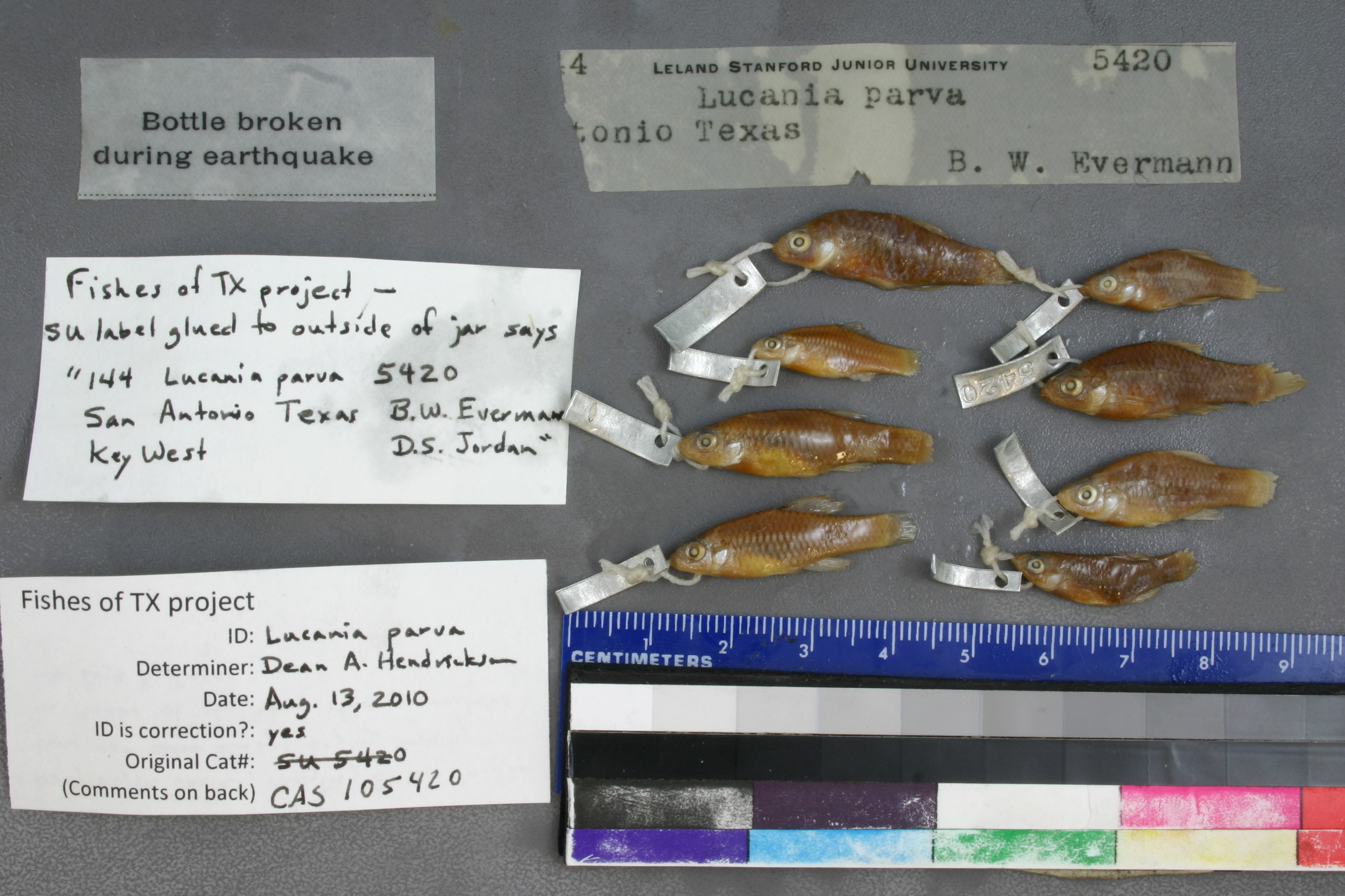
CAS_105420
Not suspect, examinedPhotos
Map
Location
29.45330° N, 98.47734° W
(± 3000
m)
Taxonomy
GenusLucania
Speciesparva
Specimen
Num Specimens0
Collection Event
CollectorB.W. EVERMANN
Collected Datenone
Geography
DrainageSan Antonio
CountryUnited States
StateTexas
CountyBexar
LocalitySAN ANTONIO, TX.
Record Source
Source
California Academy of Sciences
(type: specimens)
Institution
California Academy of Sciences
(type: museum)
Curator
Luiz Rocha
Record Added
May 13, 2010
Record Last Modified
June 22, 2022
Data Processing Track
Track 2
From Data Set Received
04/2009 to 10/2010
Identification
Suspect Notes
None
Count
No data
Current Determination
Determiner
Dean Hendrickson
Determination Date
Aug. 13, 2010
Determination Type
specimen examination
Identification Comments
ID complete | body depth varies, ranging from 3-4X in SL thus not always keying correctly in Hubbs et al., but other characters fit Page and Burr
Identification Confidence
High
Collecting Event
Collected
Dec. 2, 1891
Collector(s)
Collecting Event ID
127
Collecting Event Notes Dates found here (https://www.biodiversitylibrary.org/item/148449#page/129/mode/1up)
Field Notes
There are no field notes available.
Locality
Region
Blackland Prairies
Jurisdiction
Bexar, Texas
Name
San Antonio (north side of town at springs)
Hydrography
Texas-Gulf Region
Central Texas Coastal
San Antonio
Upper San Antonio
Headwaters San Antonio River
Olmos Creek-San Antonio River
Captive
no
Locality Photos
No locality photos available.
HUC 12
121003010201
Georeferencing Remarks
From Evermann's report (https://www.biodiversitylibrary.org/item/148449#page/138/mode/1up) it is clear he sampled San Antonio Springs and San Pedro Springs. Point placed on San Antonio Rver roughly equidistant from both and extent covers both.
Georeferencing Annotation
—
Has not been Georeferenced because
—
flag (suspect/examine)
suspect: FALSE
georeference
Error: 3000
Remarks: From Evermann's report (https://www.biodiversitylibrary.org/item/148449#page/138/mode/1up) it is clear he sampled San Antonio Springs and San Pedro Springs. Point placed on San Antonio Rver roughly equidistant from both and extent covers both.
Locality: San Antonio (north side of town at springs)Coordinates: -98.477343, 29.453297Georeferencer: Adam CohenFrom Evermann's report (https://www.biodiversitylibrary.org/item/148449#page/138/mode/1up) it is clear he sampled San Antonio Springs and San Pedro Springs. Point placed on San Antonio Rver roughly equidistant from both and extent covers both.
flag (suspect/examine)
suspect: noexamination: yes
date
note: Dates found here (https://www.biodiversitylibrary.org/item/148449#page/129/mode/1up)
date_range: 12/2/1891-12/2/1891
date
date_range: 1/1/1891-12/31/1891
collectors
collectors: Evermann, Barton Warren Dr.
staff comment
ID Status: Specimen examined and ID'ed for FoTX project
ID Comments: body depth varies, ranging from 3-4X in SL thus not always keying correctly in Hubbs et al., but other characters fit Page and Burr
ID Confidence: high
collectors
collectors: Barton Warren Evermann
date
date_range: 1/1/1891-12/31/1891
georeference
Error: 24674.4622078941Locality: San AntonioCoordinates: 29.465053486;-98.476456372Georeferencer: AECGeographic note: Inland USA Texas
Comments On CAS_105420