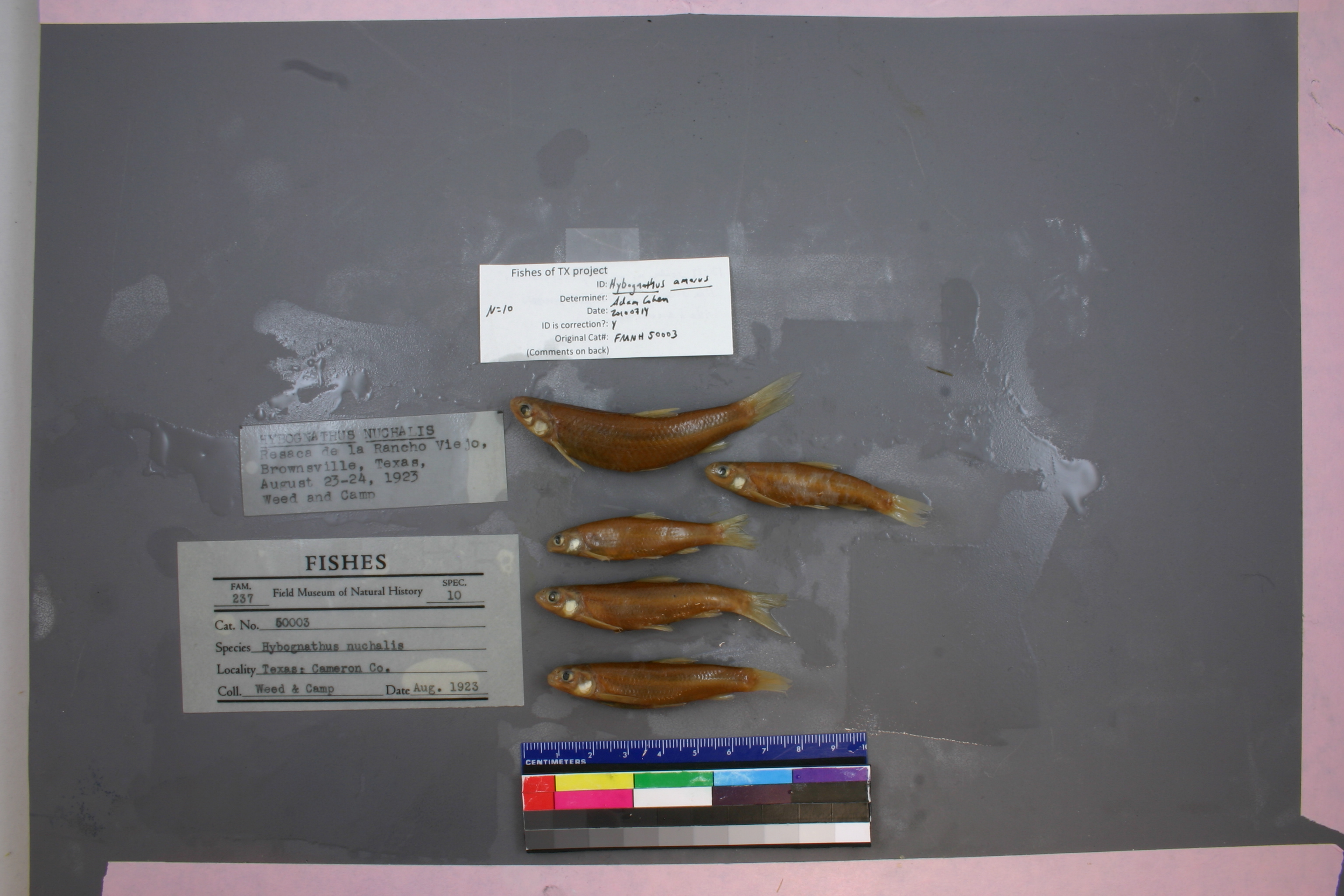
FMNH_50003
Not suspect, examined
Rio Grande Silvery Minnow –
Hybognathus amarus
Photos
Map
Location
25.96829° N, 97.45652° W
(± 9065.4
m)
Taxonomy
GenusHybognathus
Speciesnuchalis
Specimen
Num Specimens0
Collection Event
CollectorA.C. Weed and R.D. Camp
Collected Date2023.8.23
Geography
DrainageNueces-Rio Grande
CountryUnited States
StateTexas
CountyCameron
LocalityBrownsville; Resaca del Rancho Viejo.
Record Source
Source
Field Museum of Natural History
(type: specimens)
Institution
Field Museum of Natural History
(type: museum)
Curator
Mark W. Westneat
Record Added
May 13, 2010
Record Last Modified
June 22, 2022
Data Processing Track
Track 2
From Data Set Received
5/2017 to 11/2017
Identification
Suspect Notes
None
Count
No data
Current Determination
Determiner
Adam Cohen
Determination Date
July 14, 2010
Determination Type
specimen examination
Identification Comments
ID complete | 13-14 scales across belly (between lateral line scales); basioccipital process wide and amarus-like
Identification Confidence
High
Collecting Event
Collected
Aug. 23, 1923
Collector(s)
Collecting Event ID
7097
Field Notes
There are no field notes available.
Locality
Region
South Texas Brush Country
Jurisdiction
Cameron, Texas
Name
Resaca del Rancho Viejo near Brownsville
Hydrography
Texas-Gulf Region
Nueces-Southwestern Texas Coastal
Southwestern Texas Coastal
South Laguna Madre
Brownsville Ship Channel
Bahia Grande-Brownsville Ship Channel
Captive
no
Locality Photos
No locality photos available.
HUC 12
121102080900
Georeferencing Remarks
Resaca del Rancho Viejo extends far out of Brownsville so treated as shown. Reach includes Resaca del Rancho Viejo Floodway upstream to a point halfway to San Benito.
Georeferencing Annotation
—
Has not been Georeferenced because
—
flag (suspect/examine)
suspect: FALSE
flag (suspect/examine)
suspect: noexamination: yes
date
date_range: 8/23/1923-8/23/1923
collectors
collectors: Weed, A.C. Camp, R.D.
staff comment
ID Status: Specimen examined and ID'ed for FoTX project
ID Comments: 13-14 scales across belly (between lateral line scales); basioccipital process wide and amarus-like
Georef Remark: Resaca del Rancho Viejo extends far out of Brownsville so treated as shown. Reach includes Resaca del Rancho Viejo Floodway upstream to a point halfway to San Benito.
ID Confidence: high
collectors
collectors: A.C. Weed, R.D. Camp
date
date_range: 8/23/1923-8/23/1923
georeference
Error: 9065.4347519611
Remarks: Resaca del Rancho Viejo extends far out of Brownsville so treated as shown. Reach includes Resaca del Rancho Viejo Floodway upstream to a point halfway to San Benito.
Locality: Resaca del Rancho Viejo near BrownsvilleCoordinates: 25.968292751;-97.456523712Georeferencer: AECGeographic note: Inland USA TexasResaca del Rancho Viejo extends far out of Brownsville so treated as shown. Reach includes Resaca del Rancho Viejo Floodway upstream to a point halfway to San Benito.
Comments On FMNH_50003