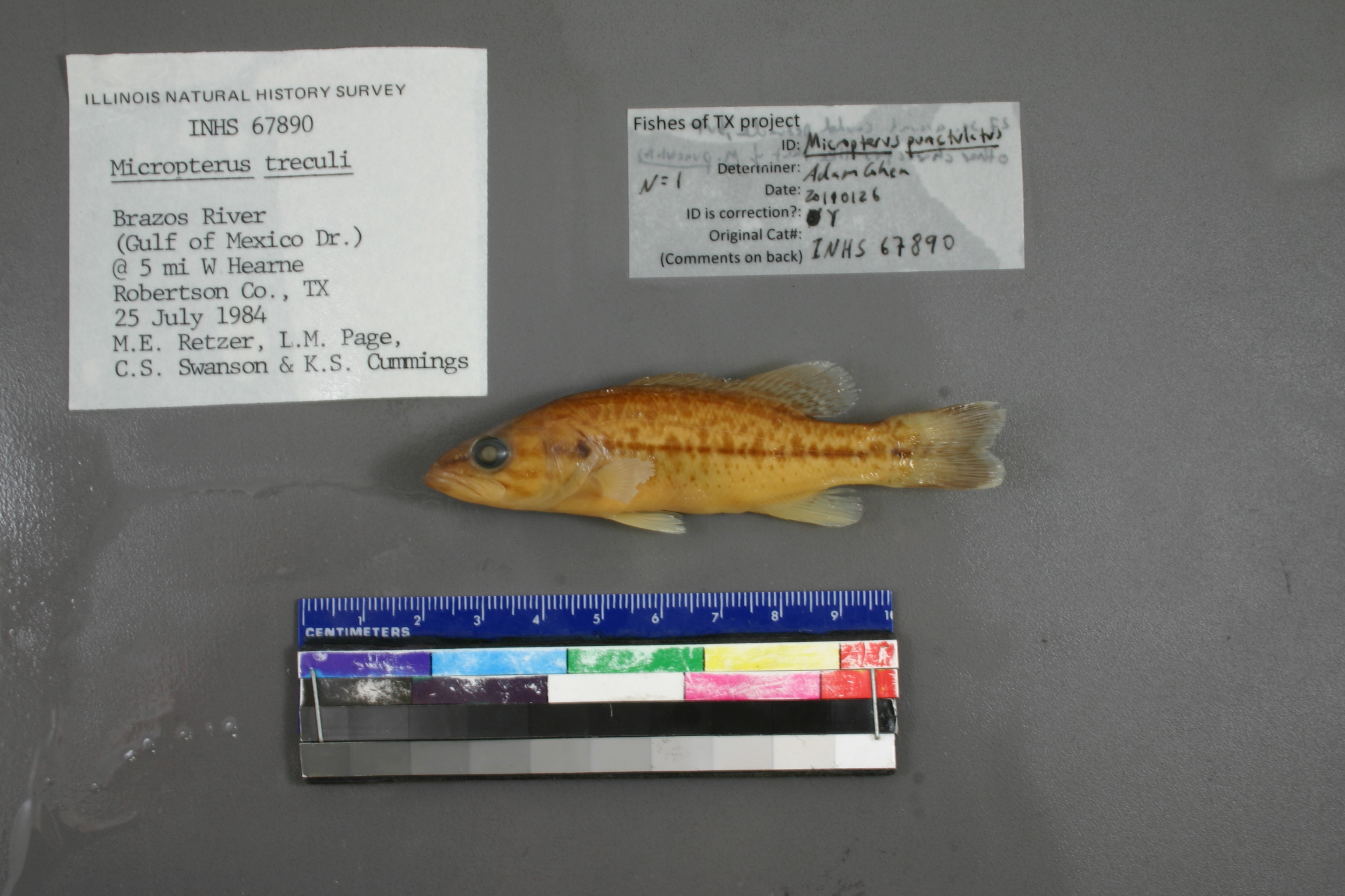
INHS_67890
Not suspect, examinedPhotos
Map
Location
30.87985° N, 96.68279° W
(± 6289.3
m)
Taxonomy
GenusMicropterus
Speciestreculi
Specimen
Num Specimens0
Collection Event
CollectorL.M.Page, C.S. Swanson, K.S. Cummings & M.E. Retze
Collected Date1984.7.25
Geography
DrainageBrazos
CountryUnited States
StateTexas
CountyRobertson
LocalityBrazos River; 5 mi WHearne
Record Source
Source
Illinois Natural History Survey
(type: specimens)
Institution
Illinois Natural History Survey
(type: museum)
Curator
Chris Taylor
Record Added
May 13, 2010
Record Last Modified
June 22, 2022
Data Processing Track
Track 2
From Data Set Received
11/1997 to 05/2006
Identification
Suspect Notes
None
Count
No data
Current Determination
Determiner
Adam Cohen
Determination Date
Jan. 26, 2011
Determination Type
specimen examination
Identification Comments
ID complete | 27 scales around caudal peduncle (more like M. treculii), but other pigmentation characters are much more like M. punctulatus
Identification Confidence
High
Collecting Event
Collected
July 25, 1984
Collector(s)
Collecting Event ID
2694
Field Notes
There are no field notes available.
Locality
Region
Oak Woods & Prairies
Jurisdiction
Robertson, Texas
Name
Brazos River West of Hearne
Hydrography
Texas-Gulf Region
Lower Brazos
Lower Brazos
Lower Brazos-Little Brazos
Cedar Creek-Brazos River
Mud Creek-Little Brazos River
Captive
no
Locality Photos
No locality photos available.
flag (suspect/examine)
suspect: FALSE
flag (suspect/examine)
suspect: noexamination: yes
date
date_range: 7/25/1984-7/25/1984
collectors
collectors: Page, Larry M. Swanson, C.S. Cummings, K.S. Retzer, Michael E.
staff comment
ID Status: Specimen examined and ID'ed for FoTX project
ID Comments: 27 scales around caudal peduncle (more like M. treculii), but other pigmentation characters are much more like M. punctulatus
Georef Remark: Point placed on river at line drawn W of city center, extent runs to river at line drawn SW of city center
ID Confidence: high
collectors
collectors: Larry M. Page, C.S. Swanson, K.S. Cummings, M.E. Retzer
date
date_range: 7/25/1984-7/25/1984
georeference
Error: 6289.31635197301
Remarks: Point placed on river at line drawn W of city center, extent runs to river at line drawn SW of city center
Locality: Brazos River West of HearneCoordinates: 30.879850442;-96.682793967Georeferencer: BJLGeographic note: Inland USA TexasPoint placed on river at line drawn W of city center, extent runs to river at line drawn SW of city center
Comments On INHS_67890