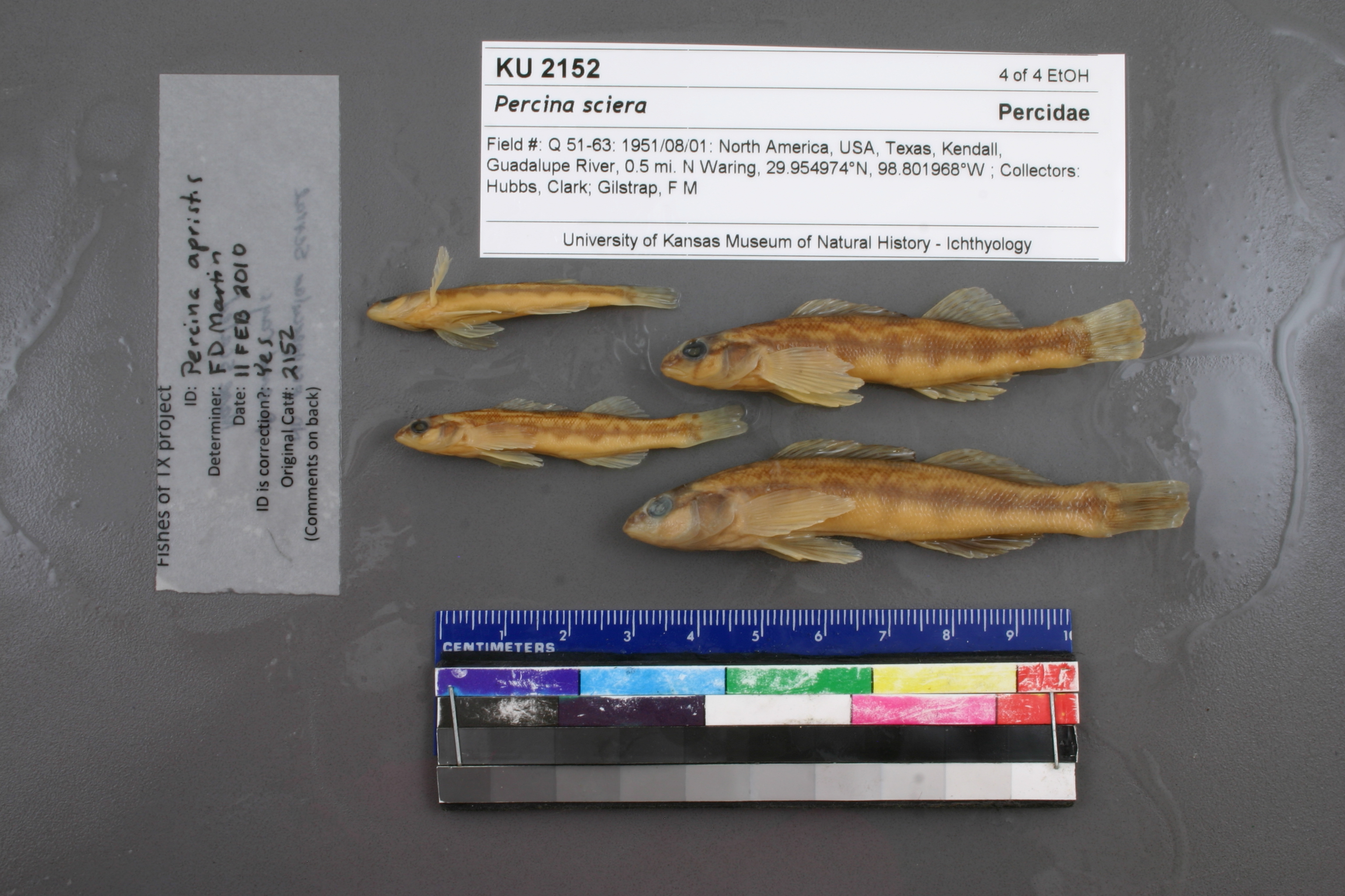
KUI_2152
Not suspect, examinedPhotos
Map
Location
29.95424° N, 98.80425° W
(± 817.5
m)
Taxonomy
GenusPercina
Speciessciera
Specimen
Num Specimens0
Identification
DeterminerFrank B. Cross
Collection Event
CollectorC. Hubbs & Frank Gilstrap
Collected Date1951.8.1
Geography
CountryUnited States
StateTexas
CountyKendall
Locality"Guadalupe River, 0.5 mi N Waring"
Record Source
Source
Natural History Museum and Biodiversity Research Center
(type: specimens)
Institution
Natural History Museum and Biodiversity Research Center
(type: museum)
Curator
Leo Smith
Record Added
May 13, 2010
Record Last Modified
March 23, 2026
Data Processing Track
Track 2
From Data Set Received
11/1997 to 05/2006
Identification
Suspect Notes
None
Count
No data
Current Determination
Determiner
Floyd Douglas Martin
Determination Date
Feb. 11, 2010
Determination Type
specimen examination
Identification Comments
ID complete | No preopercular serrae, 10 anal rays, nape scaled
Identification Confidence
High
Collecting Event
Collected
Aug. 1, 1951
Collector(s)
Collecting Event ID
7040
Field Notes
There are no field notes available.
Locality
Region
Edwards Plateau
Jurisdiction
Kendall, Texas
Name
Guadalupe River, 0.5 miles north of Waring
Hydrography
Texas-Gulf Region
Central Texas Coastal
Guadalupe
Upper Guadalupe
Block Creek-Guadalupe River
Joshua Creek-Guadalupe River
Captive
no
Locality Photos
No locality photos available.
flag (suspect/examine)
suspect: FALSE
flag (suspect/examine)
suspect: noexamination: yes
date
date_range: 8/1/1951-8/1/1951
collectors
collectors: Hubbs, Clark Gilstrap, Frank M.
staff comment
ID Status: Specimen examined and ID'ed for FoTX projectID Comments: No preopercular serrae, 10 anal rays, nape scaled
Georef Remark: Point placed on Guadalupe River due north of Waring and extents are 0.5 miles on each side of this point.
ID Confidence: high
collectors
collectors: Clark Hubbs, Frank M. Gilstrap
date
date_range: 8/1/1951-8/1/1951
georeference
Error: 817.546751996492
Remarks: Point placed on Guadalupe River due north of Waring and extents are 0.5 miles on each side of this point.
Locality: Guadalupe River, 0.5 miles north of WaringCoordinates: 29.954236519;-98.804245862Georeferencer: AECGeographic note: Inland USA TexasPoint placed on Guadalupe River due north of Waring and extents are 0.5 miles on each side of this point.
Comments On KUI_2152