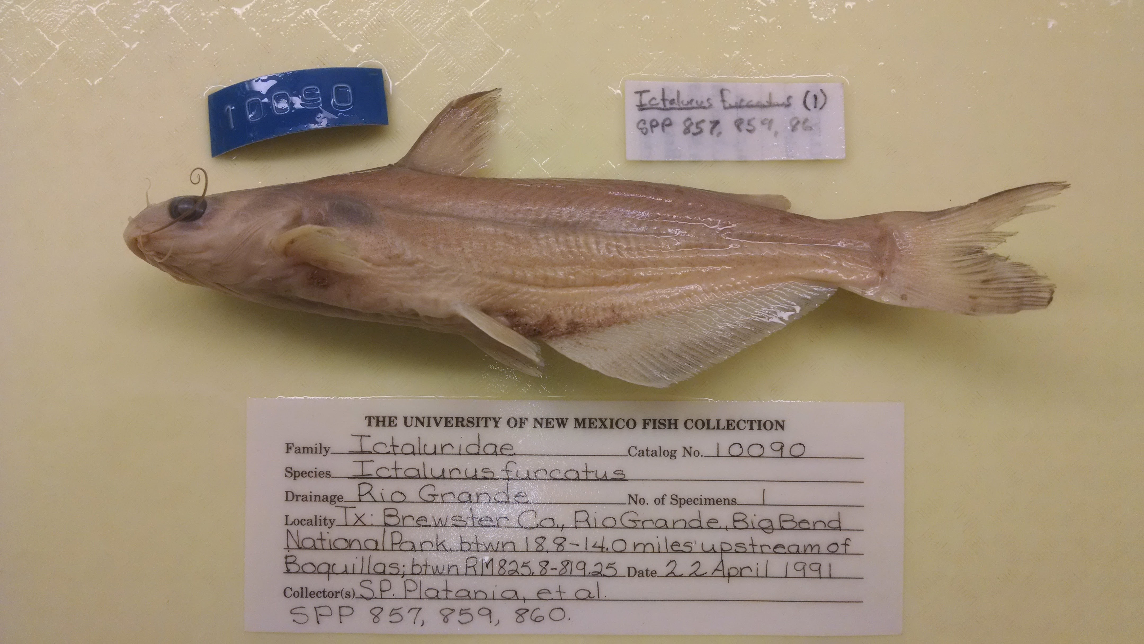
MSB_10090
Not suspect, not examinedPhotos
Map
Location
29.07416° N, 103.07844° W
(± 5645.6
m)
Taxonomy
GenusIctalurus
Speciesfurcatus
Specimen
Num Specimens1
Preparation70% EtOH
Collection Event
CollectorS.P. Platania, D.A. Young, B.M. Burr, G.L. Burton, and J.R. Green
Collected Date1991.4.22
Field NumberSPP-857Z
Geography
DrainageRIO GRANDE
StateTEXAS
CountyBREWSTER
LocalityRio Grande, in the Big Bend National Park, between 18.8 and 14 miles upstream of Boquillas, between river miles 825.8 and 819.25.
Other
Start825.8
Stop819.25
EffortCollections from SPP-857, 859, and 860 combined. AMS March 2001
Record Source
Source
Museum of Southwestern Biology
(type: specimens)
Institution
Museum of Southwestern Biology
(type: museum)
Curator
Thomas F. Turner
Record Added
April 23, 2015
Record Last Modified
June 22, 2022
Data Processing Track
Track 2
From Data Set Received
04/2009 to 10/2010
Identification
Suspect Notes
None
Count
1
Current Determination
Determiner
Fishes of Texas staff
Determination Date
Unknown
Determination Type
Unspecified
Identification Comments
None
Identification Confidence
Unknown
Collecting Event
Collected
April 22, 1991
Collector(s)
Collecting Event ID
10931
Field Notes
There are no field notes available.
Locality
Region
Trans Pecos
Jurisdiction
Brewster, Texas
Name
Rio Grande, between 18.8 and 14 miles upstream of Boquillas
Hydrography
Rio Grande Region
Rio Grande-Amistad
Rio Grande-Amistad
Big Bend
Fresno Creek-Rio Grande
Chilicotal Mountain-Rio Grande
Captive
no
Locality Photos
No locality photos available.
HUC 12
130402052006
Georeferencing Remarks
Original georeference taken from locality ID#12480. Original notes: Point is placed at midpoint of given range as measured by stream upstream of Boquillas. Half of distance between range extents is added to the starting extent. Starting point at Boquillas includes the crossing at Boquillas del Carmen and covers the river at Boquillas del Carmen and Rio Grande Village (also apparenty called Boquillas).
Georeferencing Annotation
—
Has not been Georeferenced because
—
flag (suspect/examine)
suspect: FALSE
flag (suspect/examine)
suspect: noexamination: no
flag (suspect/examine)
mark for examination, but not suspect
georeference
Error: 5645.56472
Remarks: Original georeference taken from locality ID#12480. Original notes: Point is placed at midpoint of given range as measured by stream upstream of Boquillas. Half of distance between range extents is added to the starting extent. Starting point at Boquillas includes the crossing at Boquillas del Carmen and covers the river at Boquillas del Carmen and Rio Grande Village (also apparenty called Boquillas). 0
Locality: Rio Grande River, between 18.8 and 14 miles upstream of BoquillasCoordinates: 29.07393;-103.07808Georferencer: MJCGeographic note: Inland USA TexasOriginal georeference taken from locality ID#12480. Original notes: Point is placed at midpoint of given range as measured by stream upstream of Boquillas. Half of distance between range extents is added to the starting extent. Starting point at Boquillas includes the crossing at Boquillas del Carmen and covers the river at Boquillas del Carmen and Rio Grande Village (also apparenty called Boquillas). 0
date
date_range: 4/22/1991-4/22/1991
date
date_range: 4\22\1991-4\22\1991
collectors
collectors: Platania, Steven P. Young, D.A. Burr, Brooks M. Burton, G.L. Green, J.R.
Comments On MSB_10090