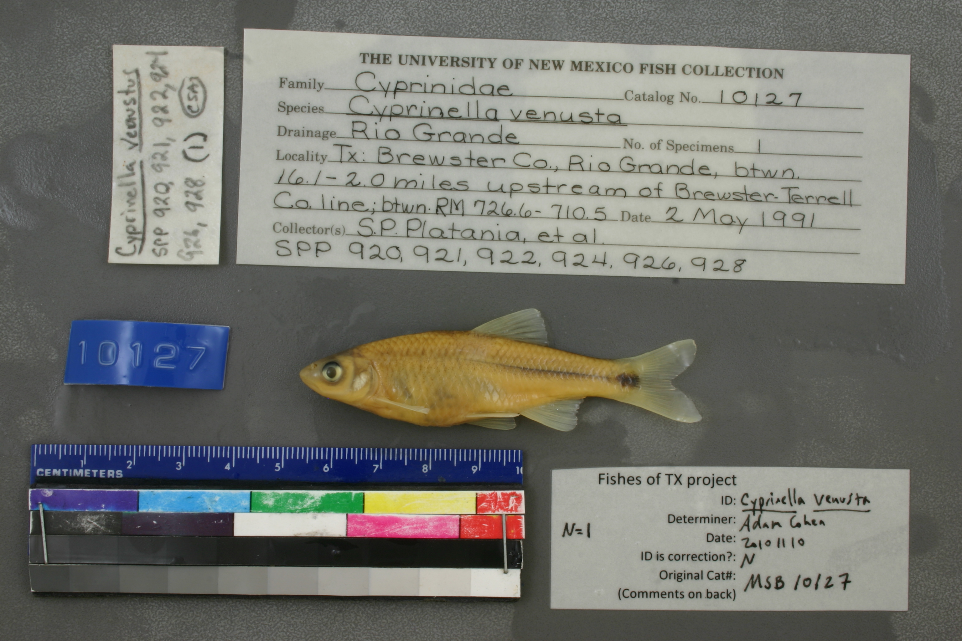
MSB_10127
Not suspect, examinedPhotos
Map
Location
29.77963° N, 102.47059° W
(± 3262.1
m)
Taxonomy
GenusCyprinella
Speciesvenusta
Specimen
Num Specimens1
Collection Event
CollectorS.P. PLATANIA, ET AL
Collected Date1991.5.2
Geography
DrainageRIO GRANDE
CountryUnited States
StateTexas
CountyBrewster
LocalityRio Grande, between 16.1 to 20 miles upstream of Brewster-Terrell County line, between river miles 726.6 and 710.5.
Record Source
Source
Museum of Southwestern Biology
(type: specimens)
Institution
Museum of Southwestern Biology
(type: museum)
Curator
Thomas F. Turner
Record Added
May 13, 2010
Record Last Modified
June 22, 2022
Data Processing Track
Track 2
From Data Set Received
04/2009 to 10/2010
Identification
Suspect Notes
None
Count
1
Current Determination
Determiner
Adam Cohen
Determination Date
Nov. 10, 2010
Determination Type
specimen examination
Identification Comments
ID complete
Identification Confidence
High
Collecting Event
Collected
May 2, 1991
Collector(s)
Collecting Event ID
7322
Field Notes
There are no field notes available.
Locality
Region
Trans Pecos
Jurisdiction
Brewster, Texas
Name
Rio Grande, between 16.1 to 20 miles upstream of Brewster/Terrell County Line
Hydrography
Rio Grande Region
Rio Grande-Amistad
Rio Grande-Amistad
Reagan-Sanderson
Reagan Canyon-Rio Grande
Mal Paso-Rio Grande
Captive
no
Locality Photos
No locality photos available.
HUC 12
130402080207
Georeferencing Remarks
Point is placed at midpoint of given range as measured by stream upstream of Brewster-Terrell County Line. Half of distance between range extents is added to the starting extent.
Georeferencing Annotation
—
Has not been Georeferenced because
—
flag (suspect/examine)
suspect: FALSE
flag (suspect/examine)
suspect: noexamination: yes
date
date_range: 5/2/1991-5/2/1991
collectors
collectors: Platania, Steven P.
staff comment
ID Status: Specimen examined and ID'ed for FoTX project
Georef Remark: Point is placed at midpoint of given range as measured by stream upstream of Brewster-Terrell County Line. Half of distance between range extents is added to the starting extent.
ID Confidence: high
collectors
collectors: Steven P. Platania
date
date_range: 5/2/1991-5/2/1991
georeference
Error: 3262.140287986
Remarks: Point is placed at midpoint of given range as measured by stream upstream of Brewster-Terrell County Line. Half of distance between range extents is added to the starting extent.
Locality: Rio Grande River, between 16.1 to 20 miles upstream of Brewster/Terrell County Line
Coordinates: 29.779633951;-102.470587385Georeferencer: AECGeographic note: Inland USA TexasPoint is placed at midpoint of given range as measured by stream upstream of Brewster-Terrell County Line. Half of distance between range extents is added to the starting extent.
Comments On MSB_10127