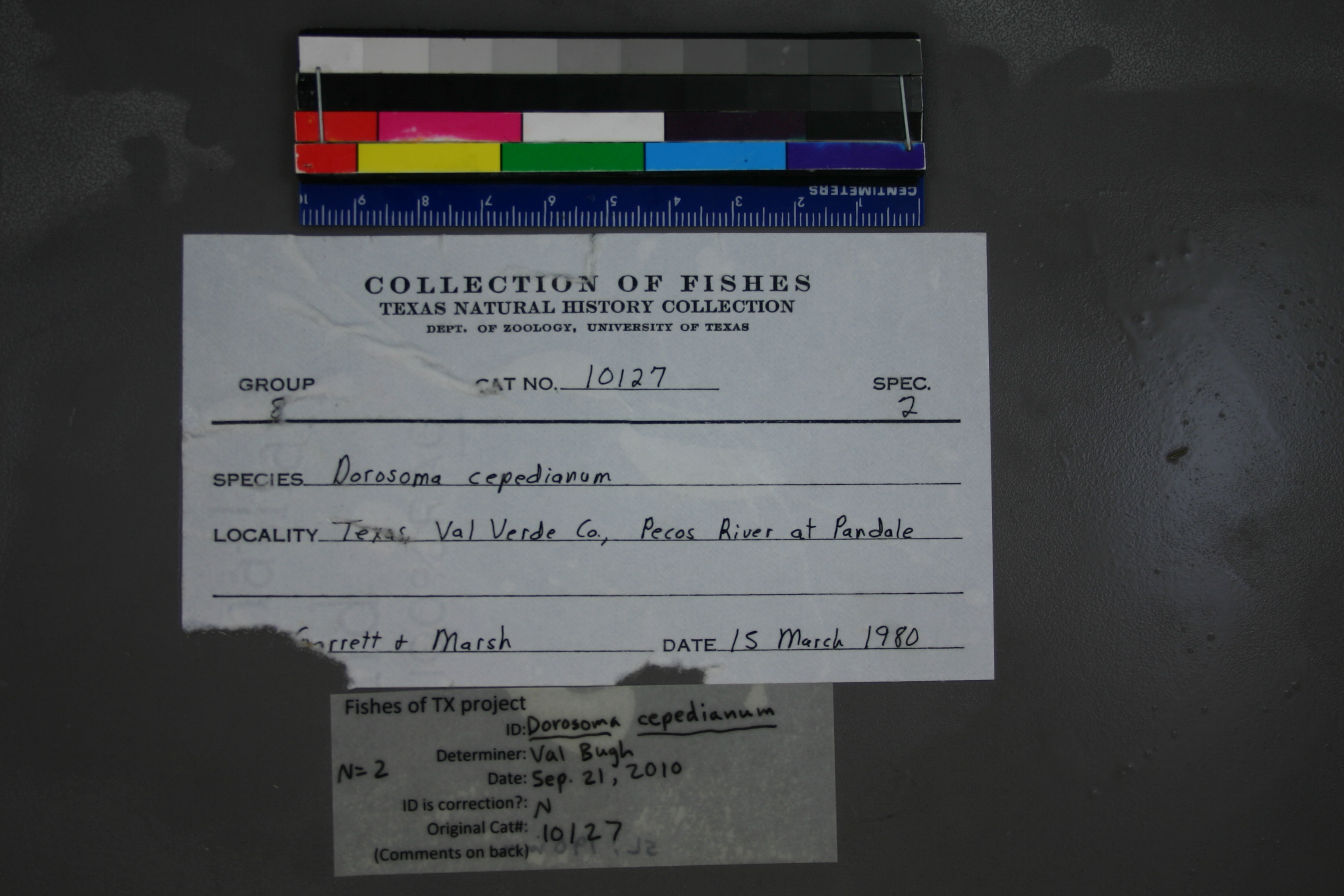
TNHCi_10127
Not suspect, examinedPhotos
Map
Location
30.12635° N, 101.57240° W
(± 500
m)
Taxonomy
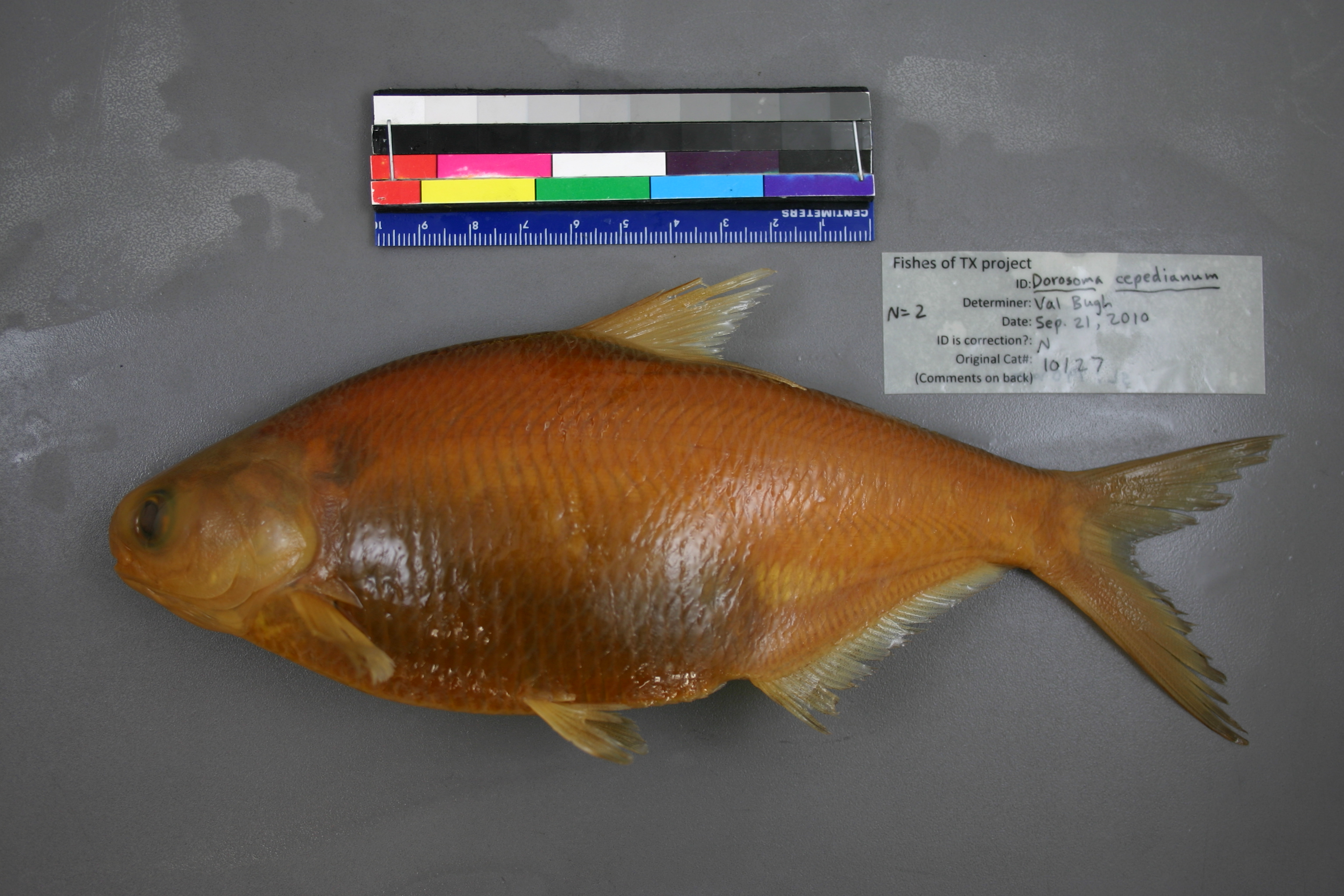
GenusDorosoma
Speciescepedianum
Specimen
Num Specimens2
Collection Event
CollectorGarrett; Marsh, E.
Collected Date1980.3.14
Geography
CountryUnknown
StateUnknown
CountyUnknown
LocalityPecos River at Pandale
Record Source
Source
Texas Natural History Collections
(type: specimens)
Institution
Texas Natural History Collections
(type: museum)
Curator
Dean Hendrickson
Record Added
May 13, 2010
Record Last Modified
March 23, 2026
Data Processing Track
Track 2
From Data Set Received
04/2009 to 10/2010
Identification
Suspect Notes
None
Count
2
Current Determination
Determiner
Valerie Gawenda Bugh
Determination Date
Sept. 21, 2010
Determination Type
specimen examination
Identification Comments
Specimen examined and Id'ed for FoTX project. | ID notes: ; MinSL(mm): 190; MaxSL(mm): ; Jar: gallon; Specimen condition: good; Mutations: none; Count Male: ; Count female: ; Extern parasites:
Identification Confidence
High
Collecting Event
Collected
March 15, 1980
Collector(s)
Collecting Event ID
10597
Field Notes
Locality
Region
Trans Pecos
Jurisdiction
Val Verde, Texas
Name
Pecos River at Pandale crossing, downstream to 1km
Hydrography
Rio Grande Region
Lower Pecos
Lower Pecos
Lower Pecos
Geddis Canyon-Pecos River
House Canyon-Pecos River
Captive
no
Locality Photos
No locality photos available.
flag (suspect/examine)
suspect: noexamination: yes
georeference
Error: 500
Remarks: Comment from Gary Garrett ('Collection was from Pandale Road Crossing (30.128259° -101.571495°) to 1 km downstream')
Locality: Pecos River at Pandale crossing, downstream to 1kmCoordinates: -101.572397, 30.126348Georeferencer: Adam CohenComment from Gary Garrett ('Collection was from Pandale Road Crossing (30.128259° -101.571495°) to 1 km downstream')
date
date_range: 3/15/1980-3/15/1980
collectors
collectors: Garrett, Gary P. Marsh-Matthews, Edie C.
staff comment
ID Status: Not flagged for specimen examination. By default we accept donor specimen determinations (after synonymization to our taxonomy). If georeferenced to TX this record has been considered in spatial context with other occurences of this species and accepted as correct.
ID Comments: NAGeoref Remark: Reach is defined by road crossings at confluences of House Canyon downstream to Henderson Draw.
collectors
collectors: Gary P. Garrett, Edie C. Marsh-Matthews
date
date_range: 3/14/1980-3/14/1980
georeference
Error: 5363.94355197699
Remarks: Reach is defined by road crossings at confluences of House Canyon downstream to Henderson Draw.
Locality: Pecos River at PandaleCoordinates: 30.177592993;-101.588676679Georeferencer: AECGeographic note: Inland USA TexasReach is defined by road crossings at confluences of House Canyon downstream to Henderson Draw.
Comments On TNHCi_10127