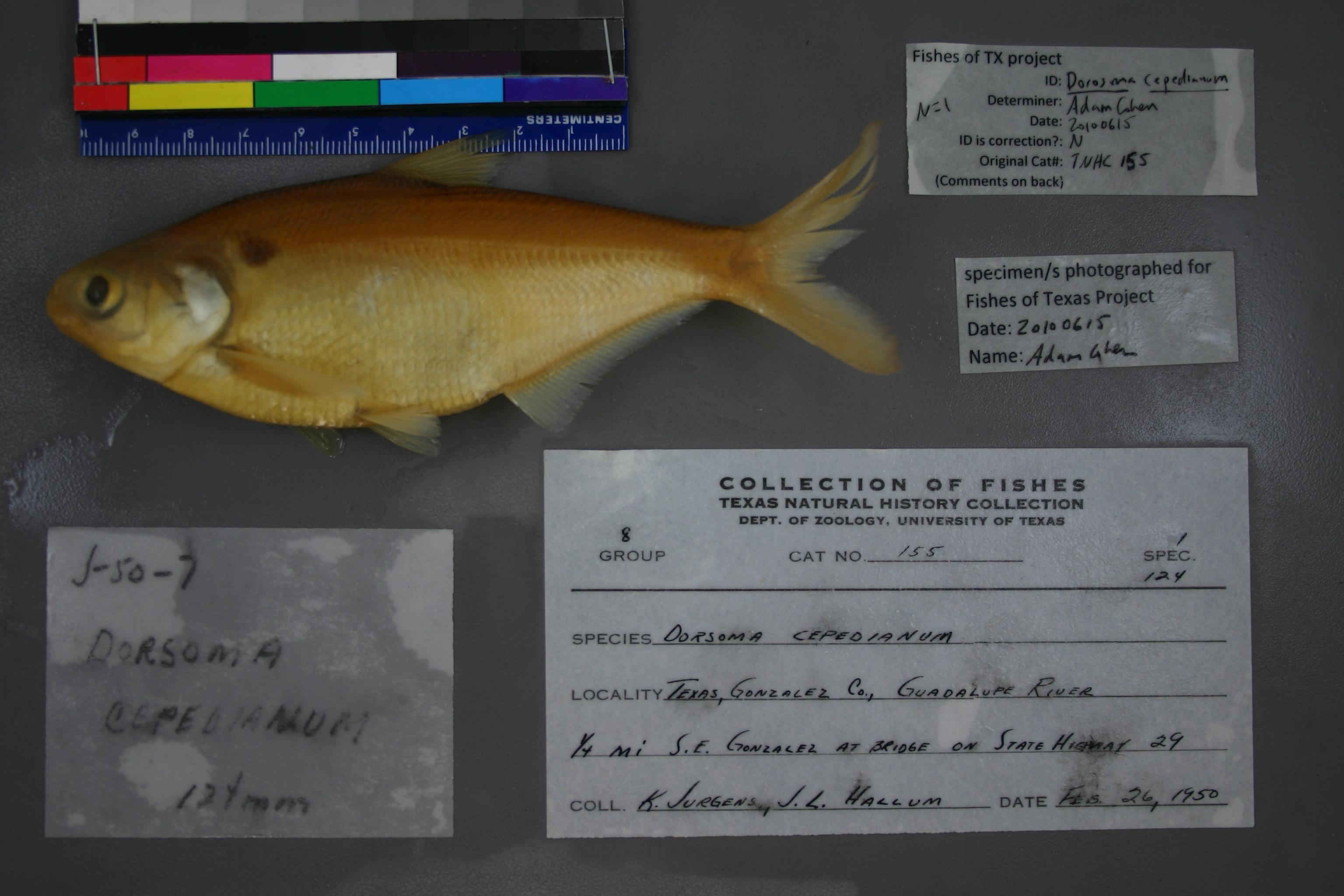
TNHCi_155
Not suspect, examinedPhotos
Map
Location
29.48453° N, 97.44765° W
(± 43.7
m)
Taxonomy
GenusDorosoma
Speciescepedianum
Specimen
Num Specimens1
Collection Event
CollectorJurgens, K., J. L. Hallum
Collected Date1950.2.25
Geography
DrainageGuadalupe
CountryUnited States
StateTexas
CountyGonzales
LocalityGuadalupe River, .25 mi. SE Gonzalez, at bridge State Hwy 29
Record Source
Source
Texas Natural History Collections
(type: specimens)
Institution
Texas Natural History Collections
(type: museum)
Curator
Dean Hendrickson
Record Added
May 13, 2010
Record Last Modified
March 23, 2026
Data Processing Track
Track 2
From Data Set Received
04/2009 to 10/2010
Identification
Suspect Notes
None
Count
1
Current Determination
Determiner
Adam Cohen
Determination Date
Feb. 11, 2016
Determination Type
specimen examination
Identification Comments
Specimen examined and Id'ed for FoTX project. | ID notes: ; MinSL(mm): 119.66; MaxSL(mm): ; Jar: quart; Specimen condition: good; Mutations: none; Count Male: ; Count female: ; Extern parasites: n
Identification Confidence
High
Collecting Event
Collected
Feb. 26, 1950
Collector(s)
Collecting Event ID
6942
Field Notes
There are no field notes available.
Locality
Region
Blackland Prairies
Jurisdiction
Gonzales, Texas
Name
Guadalupe River at US 183, 1st crossing south of Gonzales
Hydrography
Texas-Gulf Region
Central Texas Coastal
Guadalupe
Middle Guadalupe
Mill Creek-Guadalupe River
Kerr Creek-Guadalupe River
Captive
no
Locality Photos
No locality photos available.
HUC 12
121002020207
Georeferencing Remarks
Highway 29 not in this area based on USGS maps. Found from internet (http://en.wikipedia.org/wiki/State_Highway_29_(Texas)) the following statement: \"In 1951, the stretch from Liberty Hill to Gregory was reassigned to U.S. Route 183…\" So this location i
Georeferencing Annotation
Not Highway 29, but rather US 183
Has not been Georeferenced because
—
flag (suspect/examine)
suspect: noexamination: yes
date
date_range: 2/26/1950-2/26/1950
collectors
collectors: Jurgens, Kenneth C. Hallum, J.L.
collectors
collectors: Kenneth C. Jurgens, J.L. Hallum
date
date_range: 2/25/1950-2/25/1950
staff comment
ID Status: Not flagged for specimen examination. By default we accept donor specimen determinations (after synonymization to our taxonomy). If georeferenced to TX this record has been considered in spatial context with other occurences of this species and accepted as correct.
ID Comments: NAGeoref Remark: Highway 29 not in this area based on USGS maps. Found from internet (http://en.wikipedia.org/wiki/State_Highway_29_(Texas)) the following statement: 'In 1951, the stretch from Liberty Hill to Gregory was reassigned to U.S. Route 183â¦' So this location i
Georef Annotation: Not Highway 29, but rather US 183
georeference
Error: 43.665
Remarks: Highway 29 not in this area based on USGS maps. Found from internet (http://en.wikipedia.org/wiki/State_Highway_29_(Texas)) the following statement: 'In 1951, the stretch from Liberty Hill to Gregory was reassigned to U.S. Route 183â¦' So this location i Not Highway 29, but rather US 183
Locality: Guadalupe River at US 183, 1st crossing south of GonzalesCoordinates: 29.484534633;-97.447650459Georeferencer: AECGeographic note: Inland USA TexasHighway 29 not in this area based on USGS maps. Found from internet (http://en.wikipedia.org/wiki/State_Highway_29_(Texas)) the following statement: 'In 1951, the stretch from Liberty Hill to Gregory was reassigned to U.S. Route 183â¦' So this location i Not Highway 29, but rather US 183
Comments On TNHCi_155