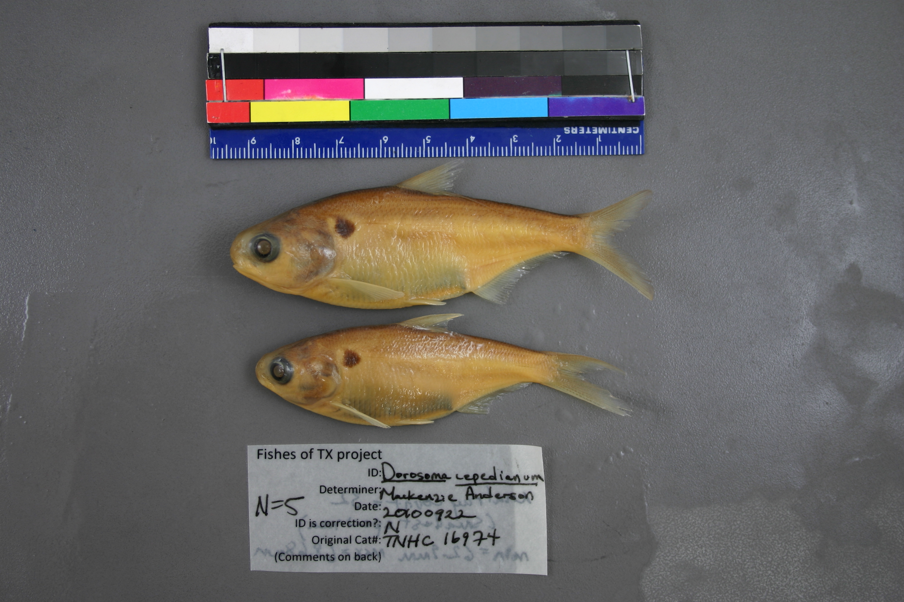
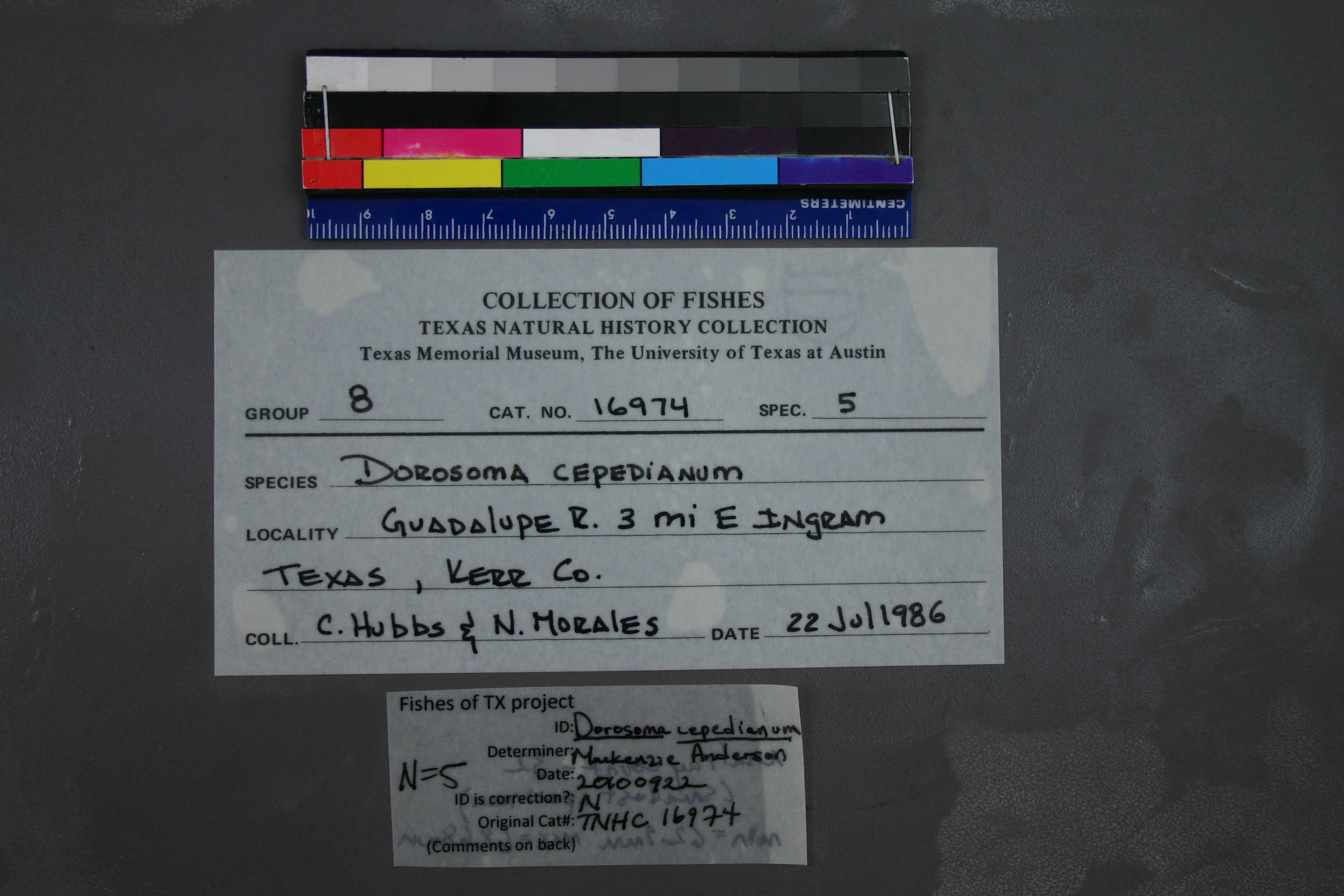
TNHCi_16974
Not suspect, examinedPhotos
Map
Location
30.06917° N, 99.19597° W
(± 2909.7
m)
Taxonomy
GenusDorosoma
Speciescepedianum
Specimen
Num Specimens5
Collection Event
CollectorHubbs, C.S.; Morales, N.
Collected Date1986.7.21
Geography
DrainageGuadalupe
CountryUnited States
StateTexas
CountyKerr
LocalityGuadalupe River 3 miles east of Ingram
Record Source
Source
Texas Natural History Collections
(type: specimens)
Institution
Texas Natural History Collections
(type: museum)
Curator
Dean Hendrickson
Record Added
May 13, 2010
Record Last Modified
March 23, 2026
Data Processing Track
Track 2
From Data Set Received
04/2009 to 10/2010
Identification
Suspect Notes
None
Count
5
Current Determination
Determiner
Mackenzie Elizabeth Anderson
Determination Date
Feb. 11, 2016
Determination Type
specimen examination
Identification Comments
Specimen examined and Id'ed for FoTX project. | ID notes: anal rays (smallest specimen): 32; MinSL(mm): 62.9; MaxSL(mm): 68.68; Jar: 8 oz; Specimen condition: good; Mutations: none; Count Male: ; Count female: ; Extern parasites:
Identification Confidence
High
Collecting Event
Collected
July 22, 1986
Collector(s)
Collecting Event ID
6770
Field Notes
Locality
Region
Edwards Plateau
Jurisdiction
Kerr, Texas
Name
Guadalupe River, 3 miles downstream of Ingram
Hydrography
Texas-Gulf Region
Central Texas Coastal
Guadalupe
Upper Guadalupe
Turtle Creek-Guadalupe River
Goat Creek-Guadalupe River
Captive
no
Locality Photos
No locality photos available.
flag (suspect/examine)
suspect: noexamination: yes
date
date_range: 7/22/1986-7/22/1986
collectors
collectors: Hubbs, Clark Morales, Nellie
collectors
collectors: Clark Hubbs, Nellie Morales
date
date_range: 7/21/1986-7/21/1986
staff comment
ID Status: Not flagged for specimen examination. By default we accept donor specimen determinations (after synonymization to our taxonomy). If georeferenced to TX this record has been considered in spatial context with other occurences of this species and accepted as correct.
ID Comments: NAGeoref Remark: Measured by stream starting at Johnson Creek confluence
georeference
Error: 2909.69395198752Remarks: Measured by stream starting at Johnson Creek confluenceLocality: Guadalupe River, 3 miles downstream of IngramCoordinates: 30.069171956;-99.195966068Georeferencer: AECGeographic note: Inland USA Texas
Measured by stream starting at Johnson Creek confluence
Comments On TNHCi_16974