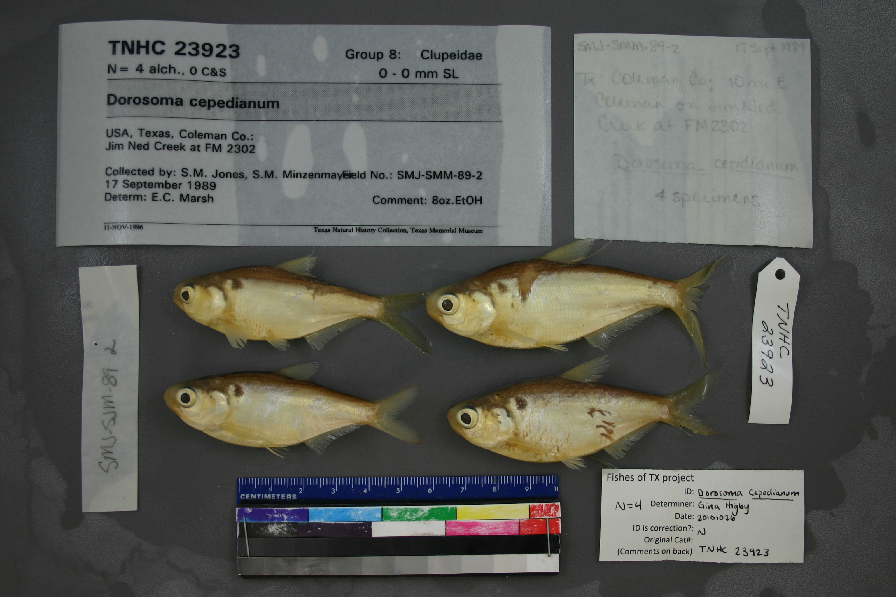
TNHCi_23923
Not suspect, examinedPhotos
Map
Location
31.87936° N, 99.27786° W
(± 90
m)
Taxonomy
GenusDorosoma
Speciescepedianum
Specimen
Num Specimens4
Identification
DeterminerE.C. Marsh
Collection Event
CollectorS.M. Jones, S.M. Minzenmayer
Collected Date1989.9.16
Geography
DrainageColorado
CountryUnited States
StateTexas
CountyColeman
LocalityJim Ned Creek at FM 2302
Record Source
Source
Texas Natural History Collections
(type: specimens)
Institution
Texas Natural History Collections
(type: museum)
Curator
Dean Hendrickson
Record Added
May 13, 2010
Record Last Modified
March 23, 2026
Data Processing Track
Track 2
From Data Set Received
04/2009 to 10/2010
Identification
Suspect Notes
None
Count
4
Current Determination
Determiner
Gina Cheryl Higby
Determination Date
Feb. 11, 2016
Determination Type
specimen examination
Identification Comments
Specimen examined and Id'ed for FoTX project. | ID notes: anal rays: 31; MinSL(mm): 82.5; MaxSL(mm): 92.5; Jar: 8 oz; Specimen condition: good; Mutations: none; Count Male: ; Count female: ; Extern parasites:
Identification Confidence
Unknown
Collecting Event
Collected
Sept. 17, 1989
Collector(s)
Collecting Event ID
23124
Field Notes
There are no field notes available.
Locality
Jurisdiction
Coleman, Texas
Name
Unknown
Hydrography
Texas-Gulf Region
Lower Colorado-San Bernard Coastal
Middle Colorado-Concho
Jim Ned
Upper Jim Ned Creek
Ranch Creek-Jim Ned Creek
Captive
no
Locality Photos
No locality photos available.
HUC 12
120901080110
Georeferencing Remarks
Georeference error, notes (if available) and coordinates extracted from GBIF (Sept2017) for FoTX Project. | GBIF latlong_remarks: Assuming creek at FM 140 (which turns into FM 2302 just W of crossing)
Georeferencing Annotation
—
Has not been Georeferenced because
—
flag (suspect/examine)
suspect: noexamination: yes
georeference
Error: 31203
Remarks: Georeference error, notes (if available) and coordinates extracted from GBIF (Sept2017) for FoTX Project.
Coordinates: -97.643253, 31.888878GBIF latlong_remarks: Unsure location of stations, so treated as: North Bosque River, Bosque County (only N Bosque occurs in county)
Georeference error, notes (if available) and coordinates extracted from GBIF (Sept2017) for FoTX Project.
date
date_range: 9/17/1989-9/17/1989
collectors
collectors: Jones, S.M. Minzenmayer, S.M.
staff comment
ID Status: Not flagged for specimen examination. By default we accept donor specimen determinations (after synonymization to our taxonomy). If georeferenced to TX this record has been considered in spatial context with other occurences of this species and accepted as correct.
ID Comments: NANot Georeferenced Because: Internal conflict since Jim Ned Creek doesn't cross SH2302
collectors
collectors: S.M. Jones, S.M. Minzenmayer
date
date_range: 9/16/1989-9/16/1989
georeference
Coordinates: ;Georeferencer: BJLGeographic note: Inland USA Texas
Comments On TNHCi_23923