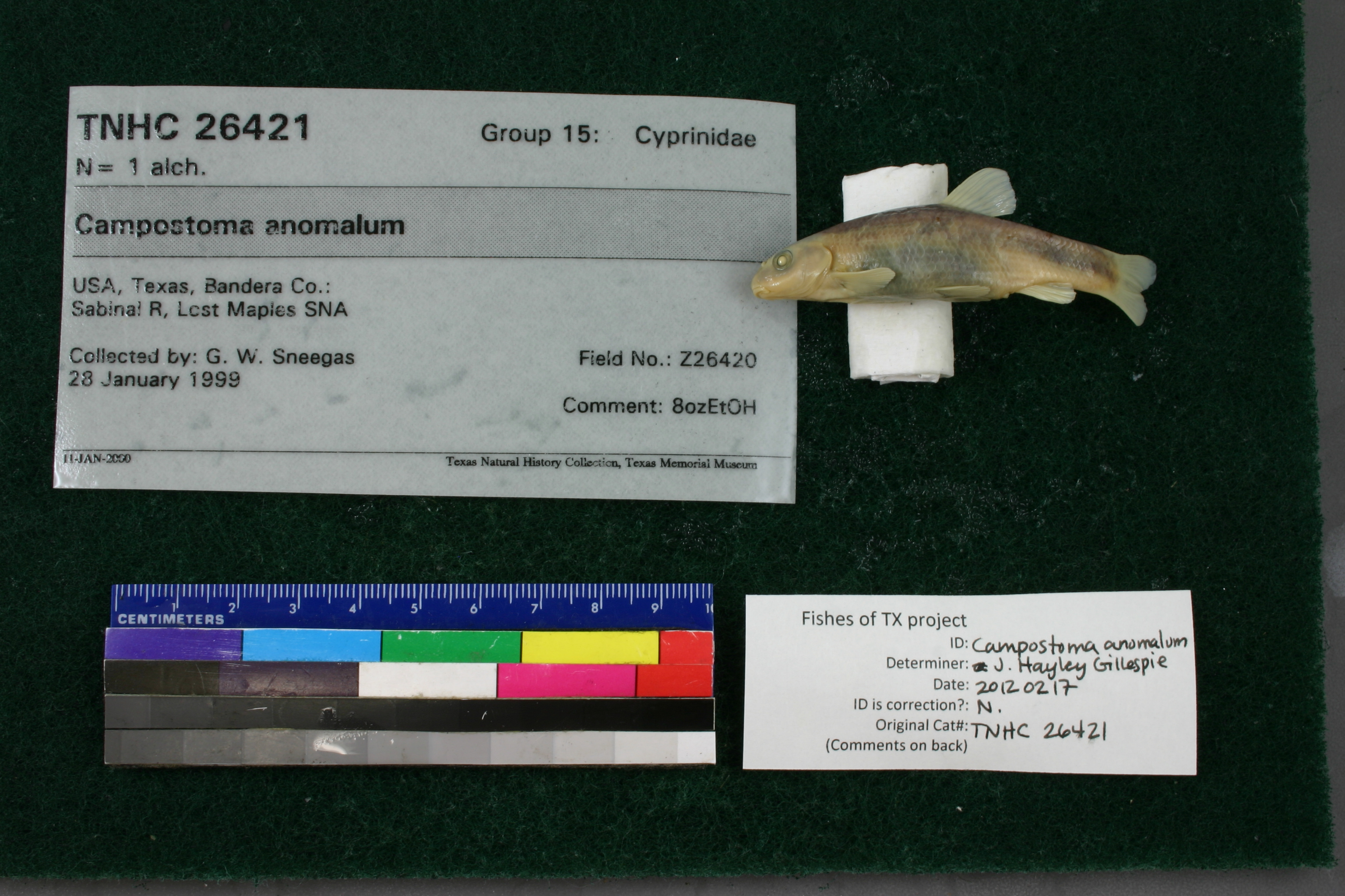
TNHCi_26421
Not suspect, examinedPhotos
Map
Location
29.80878° N, 99.57204° W
(± 760.7
m)
Taxonomy
GenusCampostoma
Speciesanomalum
Specimen
Num Specimens1
Collection Event
CollectorSneegas, G. W.
Collected Date1999.1.28
Geography
CountryUnited States
StateTexas
CountyBandera
LocalitySabinal R, Lost Maples SNA
Record Source
Source
Texas Natural History Collections
(type: specimens)
Institution
Texas Natural History Collections
(type: museum)
Curator
Dean Hendrickson
Record Added
May 13, 2010
Record Last Modified
March 23, 2026
Data Processing Track
Track 2
From Data Set Received
04/2009 to 10/2010
Identification
Suspect Notes
None
Count
1
Current Determination
Determiner
Jennifer Hayley Gillespie
Determination Date
Feb. 11, 2016
Determination Type
specimen examination
Identification Comments
Specimen examined and Id'ed for FoTX project. | ID notes: cartilaginous ridge on lower jaw present, rounded; MinSL(mm): 62.67; MaxSL(mm): ; Jar: 8 oz; Specimen condition: good; Mutations: none; Count Male: ; Count female: ; Extern parasites: n
Identification Confidence
High
Collecting Event
Collected
Jan. 28, 1999
Collector(s)
Collecting Event ID
11039
Field Notes
There are no field notes available.
Locality
Region
Edwards Plateau
Jurisdiction
Bandera, Texas
Name
Sabinal River at Lost Maples State Natural Area
Hydrography
Texas-Gulf Region
Nueces-Southwestern Texas Coastal
Nueces
Upper Frio
Upper Sabinal River
Brushy Creek-Sabinal River
Captive
no
Locality Photos
No locality photos available.
HUC 12
121101060602
Georeferencing Remarks
Assumed the reach of Sabinal River located within the boundaries of Lost Maples State Natural Area. LMSNA boundaries determined from TXDOT county map of Bandera Co and translated to Terrain Navigator.
Georeferencing Annotation
—
Has not been Georeferenced because
—
flag (suspect/examine)
suspect: noexamination: yes
date
date_range: 1/28/1999-1/28/1999
collectors
collectors: Sneegas, Garold W.
collectors
collectors: Garold W. Sneegas
date
date_range: 1/28/1999-1/28/1999
staff comment
ID Status: Not flagged for specimen examination. By default we accept donor specimen determinations (after synonymization to our taxonomy). If georeferenced to TX this record has been considered in spatial context with other occurences of this species and accepted as correct.
ID Comments: NAGeoref Remark: Assumed the reach of Sabinal River located within the boundaries of Lost Maples State Natural Area. LMSNA boundaries determined from TXDOT county map of Bandera Co and translated to Terrain Navigator.
georeference
Error: 760.727460003043
Remarks: Assumed the reach of Sabinal River located within the boundaries of Lost Maples State Natural Area. LMSNA boundaries determined from TXDOT county map of Bandera Co and translated to Terrain Navigator.
Locality: Sabinal River at Lost Maples State Natural AreaCoordinates: 29.8087798;-99.572044856Georeferencer: AECGeographic note: Inland USA TexasAssumed the reach of Sabinal River located within the boundaries of Lost Maples State Natural Area. LMSNA boundaries determined from TXDOT county map of Bandera Co and translated to Terrain Navigator.
Comments On TNHCi_26421