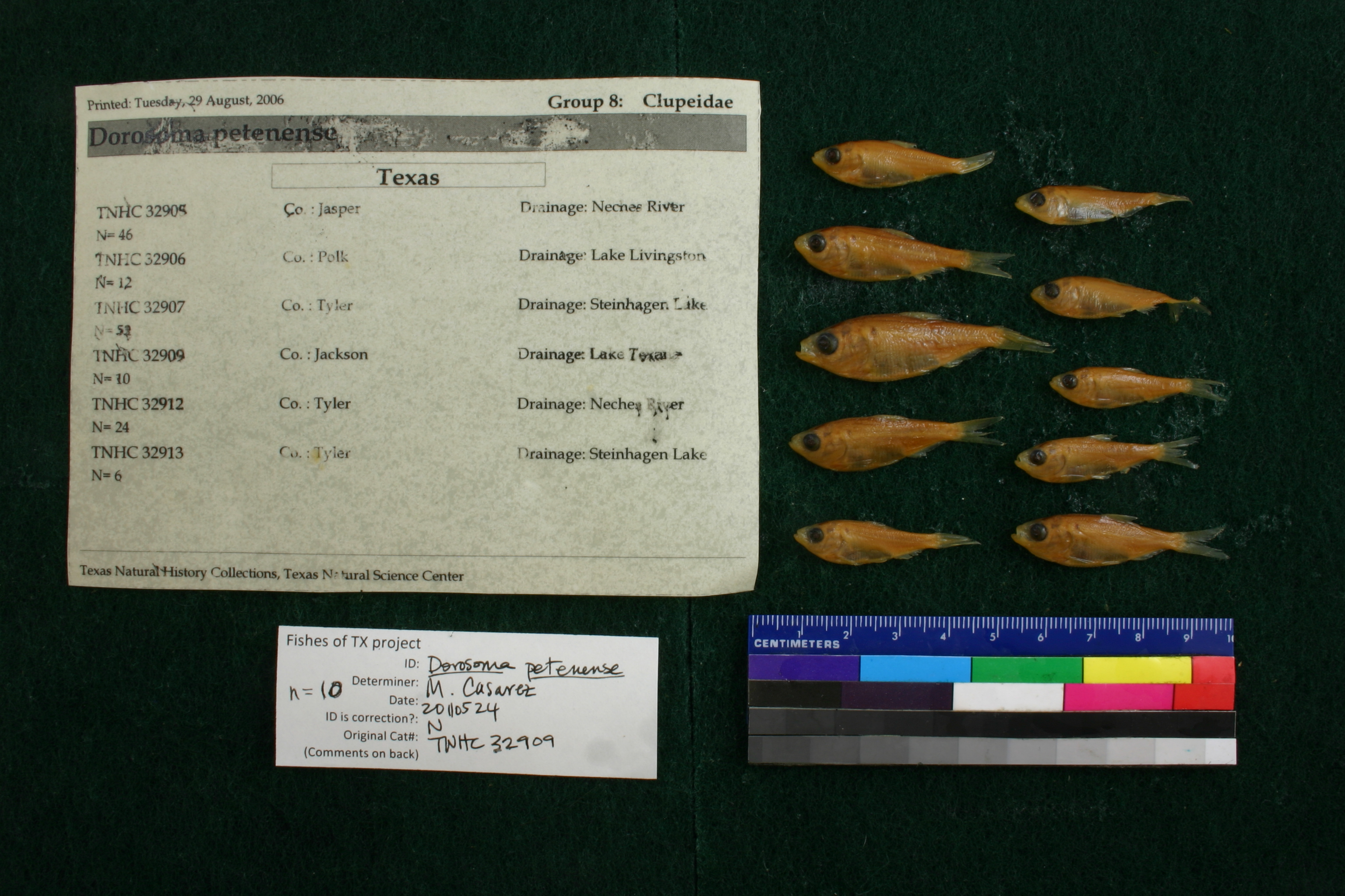
TNHCi_32909
Not suspect, examinedPhotos
Map
Location
29.02407° N, 96.50500° W
(± 210
m)
Taxonomy
FamilyClupeidae
GenusDorosoma
Speciespetenense
Specimen
Num Specimens10
Collection Event
CollectorChaney et al.
Collected Date1983.10.14-1983.10.14
Field Numberz32909
Geography
CountryUSA
StateTexas
CountyJackson
LocalityWhere 172 crosses Lake Texana at Ganado
Other
QuestionableNo
CurrentYes
NoTAIC 4172
YearEH/2006
SalinityF
Record Source
Source
Texas Natural History Collections
(type: specimens)
Institution
Texas Natural History Collections
(type: museum)
Curator
Dean Hendrickson
Record Added
April 23, 2015
Record Last Modified
March 23, 2026
Data Processing Track
Track 2
From Data Set Received
04/2009 to 10/2010
Identification
Suspect Notes
None
Count
10
Current Determination
Determiner
Melissa Casarez
Determination Date
Feb. 11, 2016
Determination Type
specimen examination
Identification Comments
Specimen examined and Id'ed for FoTX project. | ID notes: anal rays: 22,23,23; MinSL(mm): 28.69; MaxSL(mm): 42.08; Jar: 32 oz; Specimen condition: good; Mutations: none; Count Male: ; Count female: ; Extern parasites: n
Identification Confidence
High
Collecting Event
Collected
Oct. 14, 1983
Collector(s)
Collecting Event ID
41455
Field Notes
There are no field notes available.
Locality
Jurisdiction
Jackson, Texas
Name
Unknown
Hydrography
Texas-Gulf Region
Central Texas Coastal
Lavaca
Navidad
Mustang Creek-Navidad River
Devers Creek-Mustang Creek
Captive
no
Locality Photos
No locality photos available.
HUC 12
121001020502
Georeferencing Remarks
Georeference error, notes (if available) and coordinates extracted from GBIF (Sept2017) for FoTX Project. | GBIF latlong_remarks: Assuming SH 172 crossing of Mustang Creek (right above Lake Texana)
Georeferencing Annotation
—
Has not been Georeferenced because
—
georeference
Error: 210
Remarks: Georeference error, notes (if available) and coordinates extracted from GBIF (Sept2017) for FoTX Project.
Coordinates: -96.505004, 29.02407GBIF latlong_remarks: Assuming SH 172 crossing of Mustang Creek (right above Lake Texana)Georeference error, notes (if available) and coordinates extracted from GBIF (Sept2017) for FoTX Project.
flag (suspect/examine)
suspect: noexamination: yes
date
date_range: 10/14/1983-10/14/1983
date
date_range: 10\14\1983-10\14\1983
collectors
collectors: Chaney, Allan H.
Comments On TNHCi_32909