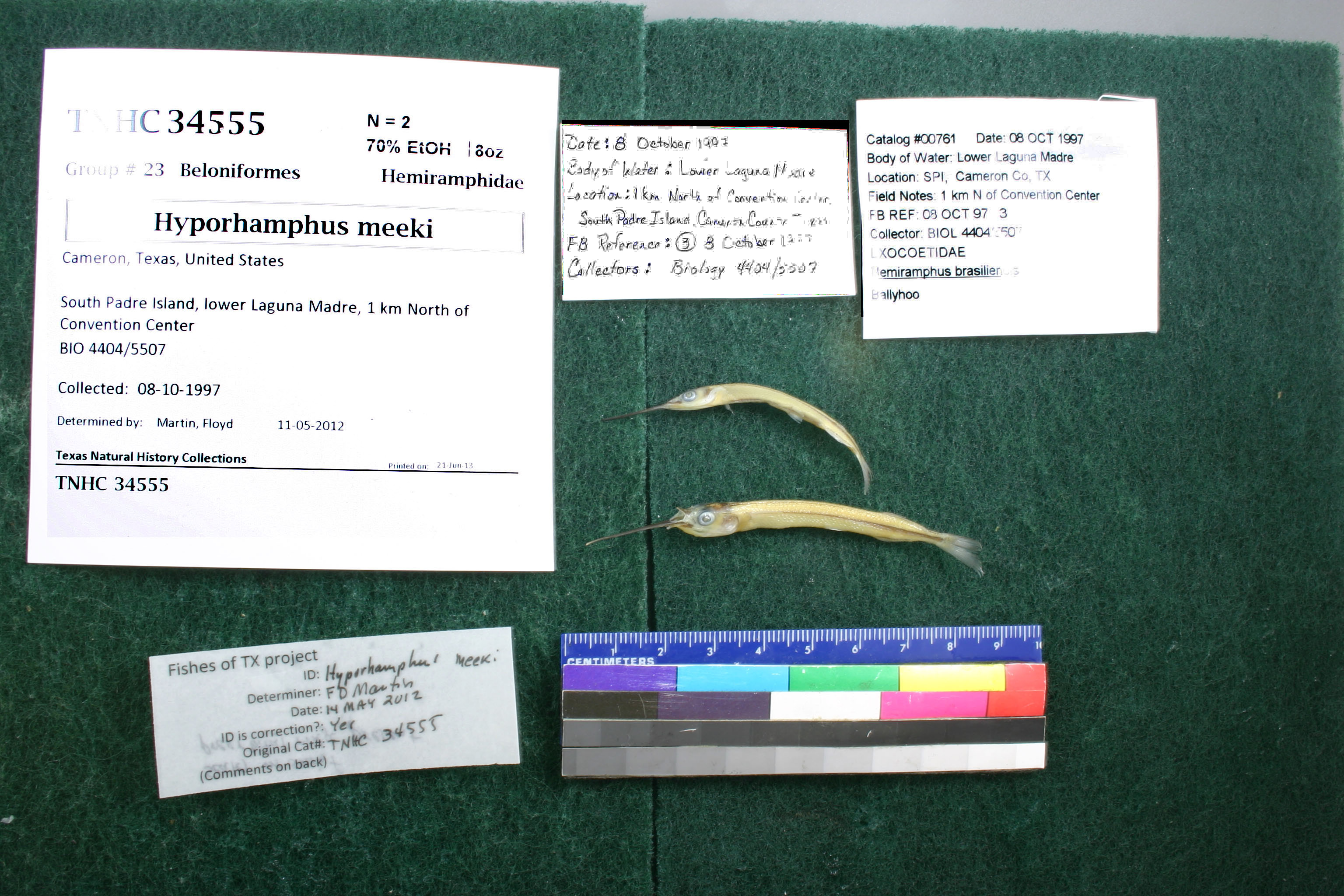
TNHCi_34555
Not suspect, examinedPhotos
Map
Location
26.14872° N, 97.17420° W
(± 551.7
m)
Taxonomy
FamilyHemiramphidae
GenusHemiramphus
Speciesbrasiliensis
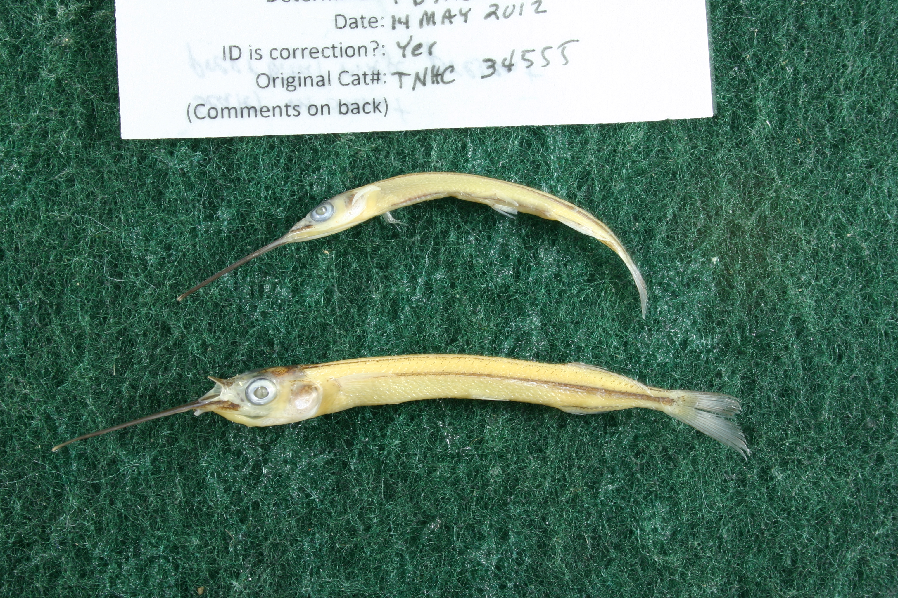
Specimen
Num Specimens2
Collection Event
CollectorBio 4404/5507
Collected Date1997.10.8-1997.10.8
Field Numberz34555
Geography
DrainageNueces-Rio Grande
CountryUSA
StateTexas
CountyCameron
LocalitySouth Padre Island, lower Laguna Madre, 1 km North of Convention Center
Other
QuestionableNo
CurrentYes
NoUTB 00761
YearJR/2007
Record Source
Source
Texas Natural History Collections
(type: specimens)
Institution
Texas Natural History Collections
(type: museum)
Curator
Dean Hendrickson
Record Added
April 23, 2015
Record Last Modified
March 23, 2026
Data Processing Track
Track 2
From Data Set Received
04/2009 to 10/2010
Identification
Suspect Notes
None
Count
2
Current Determination
Determiner
Floyd Douglas Martin
Determination Date
Feb. 11, 2016
Determination Type
specimen examination
Identification Comments
Specimen examined and Id'ed for FoTX project. | ID notes: scales on snout; preorbital ridge present; MinSL(mm): 42.44; MaxSL(mm): 57.37; Jar: 8 oz; Specimen condition: good; Mutations: none; Count Male: ; Count female: ; Extern parasites: n
Identification Confidence
High
Collecting Event
Collected
Oct. 8, 1997
Collector(s)
Collecting Event ID
19726
Field Notes
There are no field notes available.
Locality
Region
Gulf Coast Prairies & Marshes
Jurisdiction
Cameron, Texas
Name
South Padre Island, 1km north of Convention Center
Hydrography
Texas-Gulf Region
Nueces-Southwestern Texas Coastal
Southwestern Texas Coastal
South Laguna Madre
Lower Laguna Madre
Lower Laguna Madre
Captive
no
Locality Photos
No locality photos available.
HUC 12
121102081000
Georeferencing Remarks
The location was set at 1 km distance from the convention center at heading 350, with the extent of the location set at 540 meters. This extent size encompasses ~1 km of area including the eastern edge of the island to the western edge of the mud flats, l
Georeferencing Annotation
—
Has not been Georeferenced because
—
flag (suspect/examine)
suspect: noexamination: yes
flag (suspect/examine) note
This lot in need of examination, but not yet examined. Work in progress.
flag (suspect/examine)
out of range, check specimen
date
date_range: 10/8/1997-10/8/1997
date
date_range: 10\8\1997-10\8\1997
collectors
collectors: Bio 4404/5507
Comments On TNHCi_34555