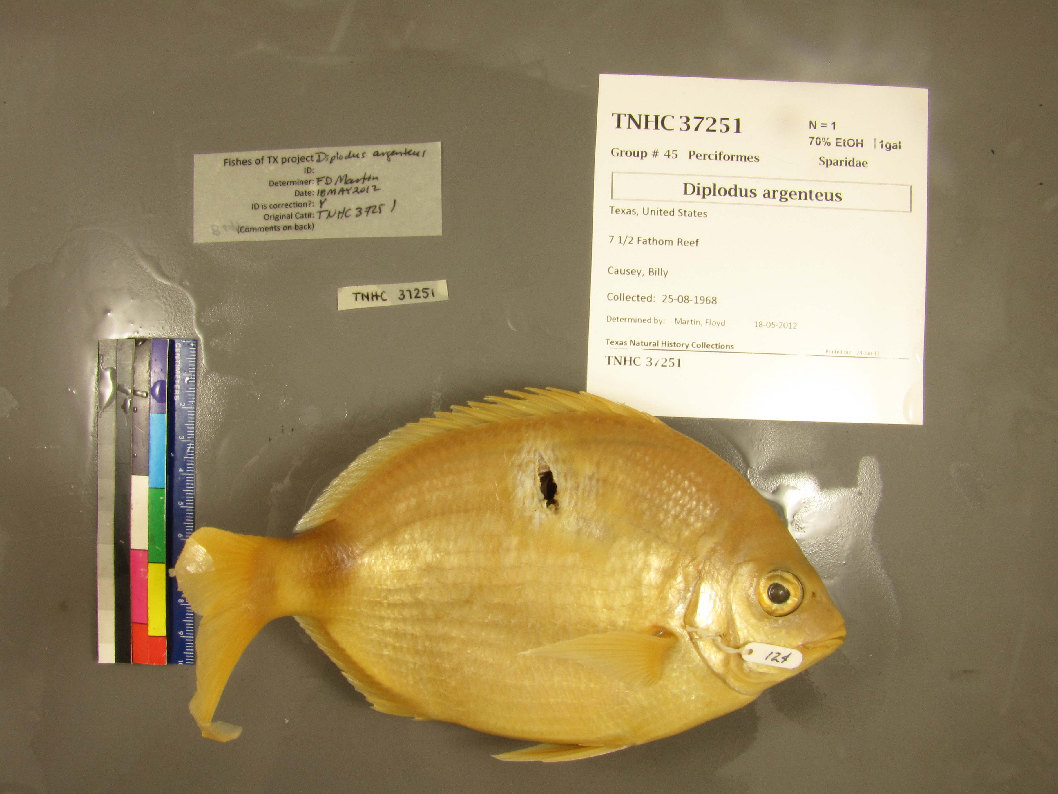
TNHCi_37251
Suspect, pending examinationPhotos
Map
Location
26.81412° N, 97.20508° W
(± 3400
m)
Taxonomy
FamilySparidae
GenusDiplodus
Speciesholbrooki
Specimen
Num Specimens1
Collection Event
CollectorCausey,
Collected Date1968.8.25-1968.8.25
Field Numberz35602
Geography
CountryUSA
StateTexas
Locality7 1/2 fathom reef
Other
QuestionableNo
CurrentYes
NoTAIC 124
YearLC/2007
Record Source
Source
Texas Natural History Collections
(type: specimens)
Institution
Texas Natural History Collections
(type: museum)
Curator
Dean Hendrickson
Record Added
April 23, 2015
Record Last Modified
March 23, 2026
Data Processing Track
Track 2
From Data Set Received
04/2009 to 10/2010
Identification
Suspect Notes
added as bulk process; species not known from study area
Count
1
Current Determination
Determiner
Floyd Douglas Martin
Determination Date
Feb. 11, 2016
Determination Type
specimen examination
Identification Comments
Specimen examined and Id'ed for FoTX project. | ID notes: 8 upper incisors; MinSL(mm): 152; MaxSL(mm): ; Jar: gallon; Specimen condition: good; Mutations: none; Count Male: ; Count female: ; Extern parasites: n
Identification Confidence
High
Collecting Event
Collected
Aug. 25, 1968
Collector(s)
Collecting Event ID
43669
Field Notes
There are no field notes available.
Locality
Jurisdiction
Gulf of Mexico, North America
Name
Seven and One Half Fathom Bank
Hydrography
Not available
Captive
no
Locality Photos
No locality photos available.
HUC
—
Georeferencing Remarks
From this thesis almost certainly (Causey, B.D. 1969. The fish fauna of seven and one-half fathom reef, northwestern Gulf of Mexico. M.Sc. Thesis, Texas A and I Univ., Kingsville, Texas. 110 pp.). Coordinates found here (https://www.gulfbase.org/geological-feature/seven-and-one-half-fathom-bank), but when projected in Google Maps they do not allign with a nearby elevated area. Point shifted to this elevated area which is assumed to be the reef.
Georeferencing Annotation
—
Has not been Georeferenced because
—
flag (suspect/examine)
note: Suspect record remains to be resolved after an initial examination. This record has become somewhat of a research project. Comments that could help resolve the locality or determination are solicited.
Examination: Pending
georeference
Error: 3400
Remarks: From this thesis almost certainly (Causey, B.D. 1969. The fish fauna of seven and one-half fathom reef, northwestern Gulf of Mexico. M.Sc. Thesis, Texas A and I Univ., Kingsville, Texas. 110 pp.). Coordinates found here (https://www.gulfbase.org/geological-feature/seven-and-one-half-fathom-bank), but when projected in Google Maps they do not allign with a nearby elevated area. Point shifted to this elevated area which is assumed to be the reef.
Locality: Seven and One Half Fathom BankCoordinates: -97.205079, 26.814125Georeferencer: Adam CohenFrom this thesis almost certainly (Causey, B.D. 1969. The fish fauna of seven and one-half fathom reef, northwestern Gulf of Mexico. M.Sc. Thesis, Texas A and I Univ., Kingsville, Texas. 110 pp.). Coordinates found here (https://www.gulfbase.org/geological-feature/seven-and-one-half-fathom-bank), but when projected in Google Maps they do not allign with a nearby elevated area. Point shifted to this elevated area which is assumed to be the reef.
flag (suspect/examine)
suspect: noexamination: yes
date
date_range: 8/25/1968-8/25/1968
date
date_range: 8\25\1968-8\25\1968
collectors
collectors: Causey
Comments On TNHCi_37251