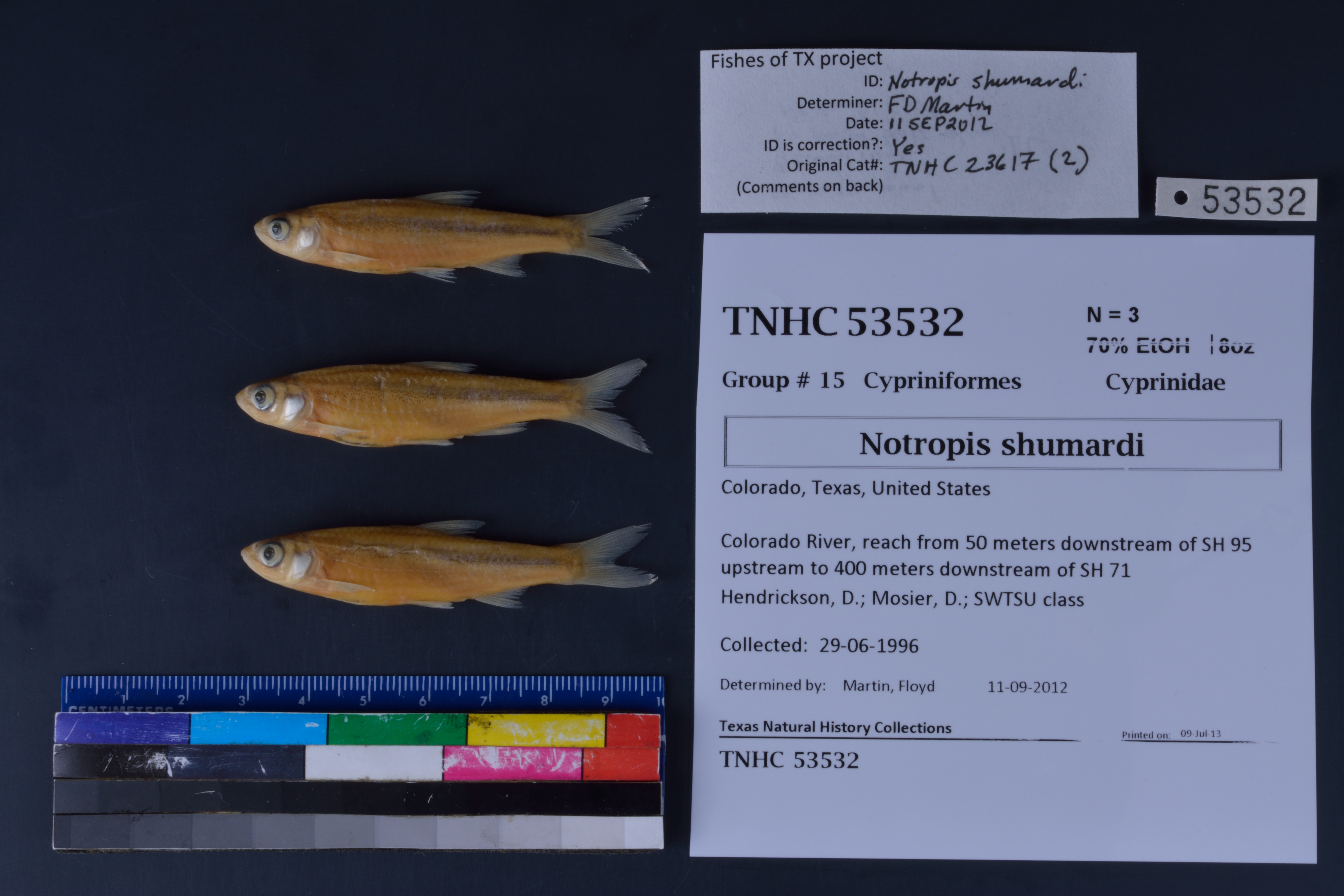
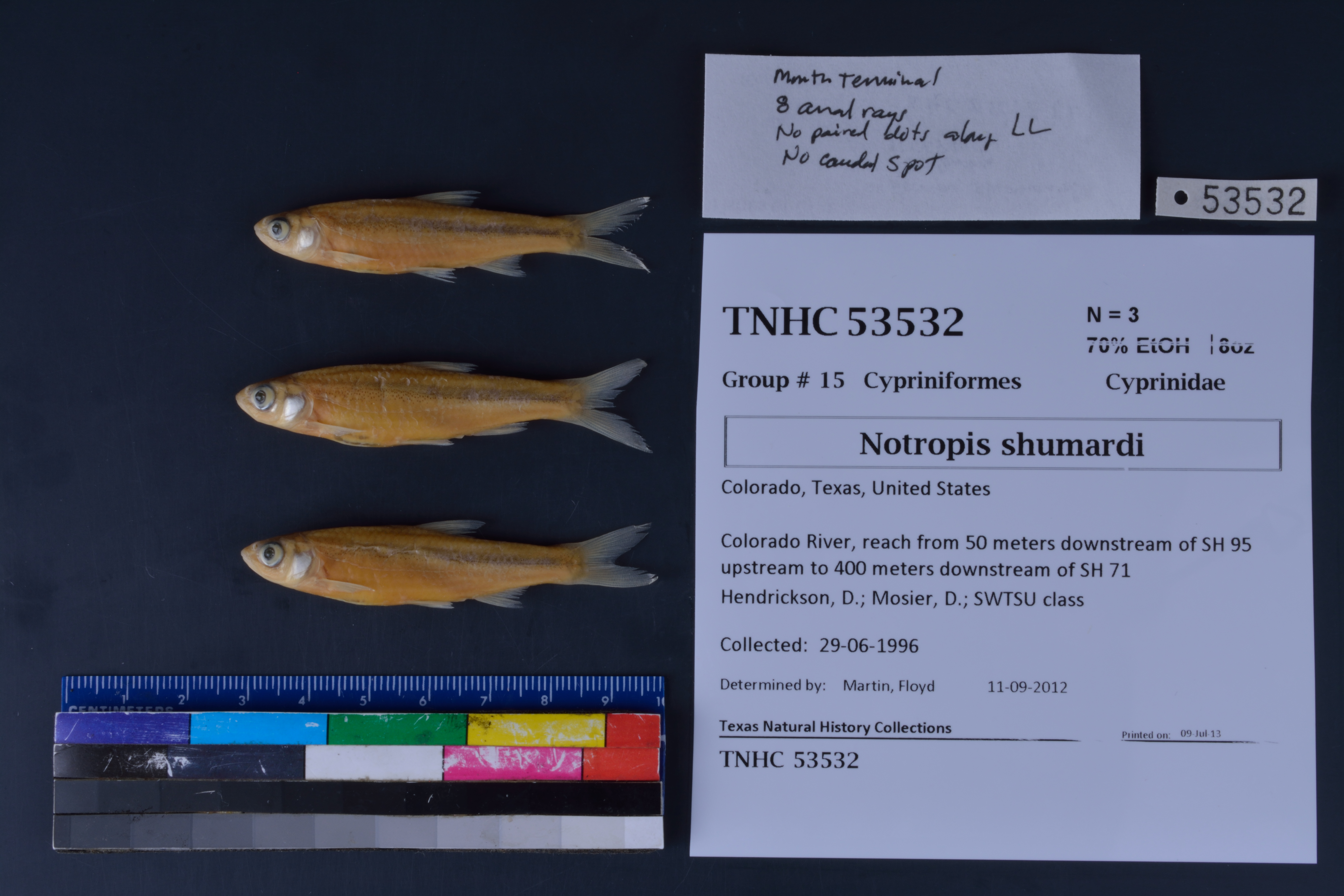
TNHCi_53532
Suspect, pending examinationPhotos
Map
Location
30.02295° N, 97.26389° W
(± 9145.9
m)
Taxonomy
FamilyCyprinidae
GenusNotropis
Speciesshumardi
Specimen
Num Specimens3
PreparationFluid - 3
Identification
Identification RemarksFDM notes: mouth terminal; 8 anal rays; no paired dots along LL; no caudal spot
Identified ByMartin, Floyd
Date Identified2012.9.11
Collection Event
CollectorHendrickson, D.; Mosier, D.; SWTSU class
Collected Date1996.6.29
Field NumberDAH960629-01
Event RemarksUsed electro shocker, trammel net & seines, day & night, bottom bedrock and mud. Old coll. method: : Boat electrofisher & seine
Geography
CountryUnited States
StateTexas
CountyColorado
LocalityColorado River, reach from 50 meters downstream of SH 95 upstream to 400 meters downstream of SH 71
Latitude30.022947
Longitude-97.263887
DatumWGS84
Error9145.901952
Georeferencing
Georeference RemarksSH 71 crosses at least two places on the Colorado River. It is assumed that this collection was made going upstream of SH 95. This is in Bastrop County not Colorado County.
Record
Occurrence RemarksSpecimens removed from TNHC 23617 due to redetermination 09July2013
Record Source
Source
Texas Natural History Collections
(type: specimens)
Institution
Texas Natural History Collections
(type: museum)
Curator
Dean Hendrickson
Record Added
June 24, 2020
Record Last Modified
March 23, 2026
Data Processing Track
Track 3
From Data Set Received
5/2017 to 11/2017
Identification
Suspect Notes
None
Count
3
Current Determination
Determiner
Unknown
Determination Date
Unknown
Determination Type
Unspecified
Identification Comments
None
Identification Confidence
Unknown
Collecting Event
Collected
June 29, 1996
Collector(s)
Collecting Event ID
347044
Field Notes
There are no field notes available.
Locality
Jurisdiction
Bastrop, Texas
Name
Colorado River, reach from 50 meters downstream of SH 95 upstream to 400 meters downstream of SH 71
Hydrography
Texas-Gulf Region
Lower Colorado-San Bernard Coastal
Lower Colorado
Lower Colorado-Cummins
Alum Creek-Colorado River
Little Piney Creek-Colorado River
Captive
no
Locality Photos
No locality photos available.
HUC 12
120903010401
Georeferencing Remarks
Georeference needs verification/refinement; coordinates provided by donor
Georeferencing Annotation
—
Has not been Georeferenced because
This record, being part of the track 3 import, is not formally georeferenced by FoTX staff at this time. However, to allow mapping and visualization of this record, locality information has been provisionally accepted if provided by the donor or if location text could be matched to previously georeferenced records by FoTX team or donor data. For many records spatial error is either accepted from the donor (when provided) or derived based on coordinate precision.
flag (suspect/examine)
note: suspect record needs to be examinedExamination: Pending
Comments On TNHCi_53532