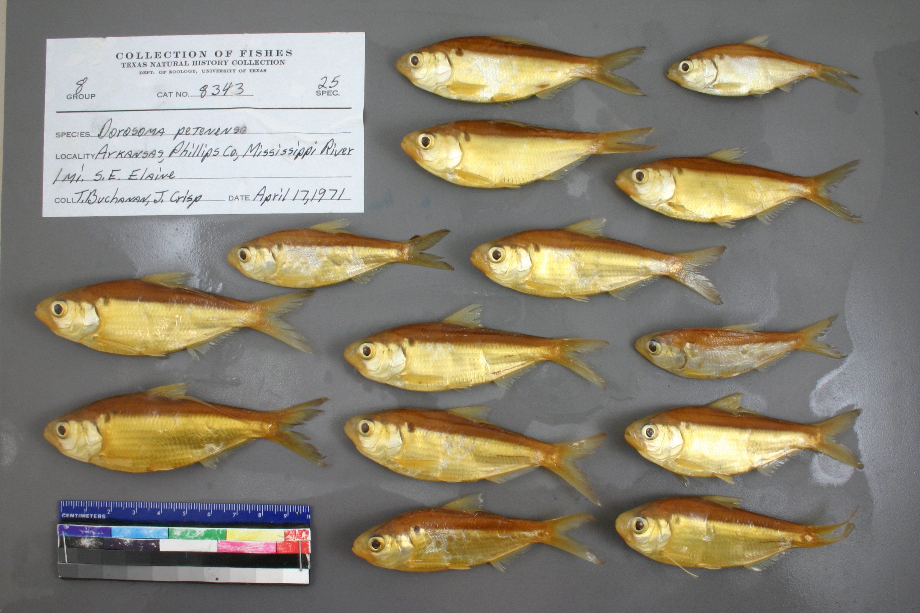
TNHCi_8343
Not suspect, examinedPhotos
Map
Location
34.27779° N, 90.83403° W
(± 2253
m)
Taxonomy
FamilyClupeidae
GenusDorosoma
Speciespetenense
Specimen
Num Specimens25
Collection Event
CollectorBuchanan, T.; Crisp, J.
Collected Date1971.4.17-1971.4.17
Field NumberZ8343TMB-71-10
Geography
DrainageWaterBody: Mississippi
CountryUSA
StateArkansas
CountyPhillips
LocalityMississippi River, 1 mi. SE Elaine
Other
Min Sl0
Max Sl0
QuestionableNo
CurrentYes
SalinityF
Record Source
Source
Texas Natural History Collections
(type: specimens)
Institution
Texas Natural History Collections
(type: museum)
Curator
Dean Hendrickson
Record Added
April 23, 2015
Record Last Modified
March 23, 2026
Data Processing Track
Track 2
From Data Set Received
04/2009 to 10/2010
Identification
Suspect Notes
None
Count
25
Current Determination
Determiner
Melissa Casarez
Determination Date
April 7, 2011
Determination Type
specimen examination
Identification Comments
Specimen examined and Id'ed for FoTX project. | ID notes: anal rays: 22,23; MinSL(mm): 58.8; MaxSL(mm): 89.55; Jar: 32 oz; Specimen condition: good; Mutations: none; Count Male: ; Count female: ; Extern parasites: n
Identification Confidence
High
Collecting Event
Collected
April 17, 1971
Collector(s)
Collecting Event ID
49594
Field Notes
There are no field notes available.
Locality
Jurisdiction
Phillips, Arkansas
Name
Unknown
Hydrography
Lower Mississippi Region
Lower Mississippi-St. Francis
Lower Mississippi-Helena
Lower Mississippi-Helena
DeSoto Lake-Mississippi River
80201000200
Captive
no
Locality Photos
No locality photos available.
HUC 12
080201000200
Georeferencing Remarks
Georeference error, notes (if available) and coordinates extracted from GBIF (Sept2017) for FoTX Project. | GBIF latlong_remarks: Measured distance doesn't land near water either by road or by air. Point placed on nearest point of river to measurement, with uncertainty found using MaNIS.net georeferencing calculator.
Georeferencing Annotation
—
Has not been Georeferenced because
—
georeference
Error: 2253
Remarks: Georeference error, notes (if available) and coordinates extracted from GBIF (Sept2017) for FoTX Project.
Coordinates: -90.834028, 34.277789GBIF latlong_remarks: Measured distance doesn't land near water either by road or by air. Point placed on nearest point of river to measurement, with uncertainty found using MaNIS.net georeferencing calculator.
Georeference error, notes (if available) and coordinates extracted from GBIF (Sept2017) for FoTX Project.
flag (suspect/examine)
suspect: noexamination: yes
date
date_range: 4/17/1971-4/17/1971
date
date_range: 4\17\1971-4\17\1971
collectors
collectors: Buchanan, Thomas M. Crisp, J.
Comments On TNHCi_8343