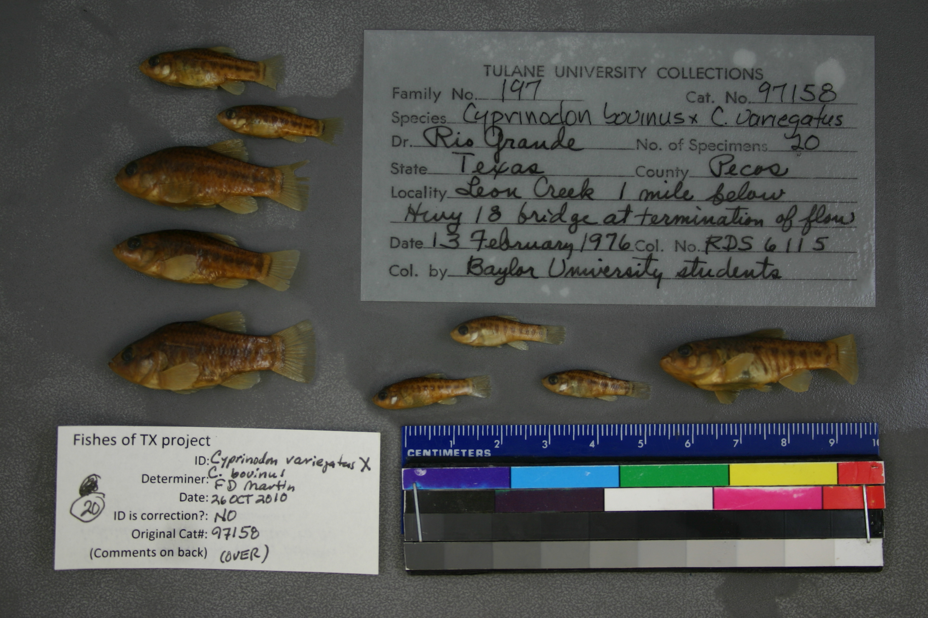
TU_97158
Not suspect, examinedPhotos
Map
Location
31.05199° N, 102.88100° W
(± 1652.8
m)
Taxonomy
GenusCyprinodon
Speciesbovinus
Hybrid Speciesx variegatus
Specimen
Num Specimens0
Identification
DeterminerR.D. Suttkus/1976
Collection Event
CollectorBaylor University students
Collected Date1976.2.13
Geography
DrainageRio Grande
CountryUnited States
StateTexas
CountyPecos
LocalityLeon Creek, 1 mi. below Hwy. 18 bridge at termination of flow.
Record Source
Source
Tulane Museum of Natural History
(type: specimens)
Institution
Tulane Museum of Natural History
(type: museum)
Curator
Henry L. Bart
Record Added
May 13, 2010
Record Last Modified
July 27, 2022
Data Processing Track
Track 1
From Data Set Received
11/1997 to 05/2006
Identification
Suspect Notes
None
Count
No data
Current Determination
Determiner
Floyd Douglas Martin
Determination Date
Oct. 26, 2010
Determination Type
specimen examination
Identification Comments
ID complete
Identification Confidence
High
Collecting Event
Collected
Feb. 13, 1976
Collector(s)
Collecting Event ID
1894
Field Notes
There are no field notes available.
Locality
Region
Trans Pecos
Jurisdiction
Pecos, Texas
Name
Diamond Y Draw, 1 mile downstream of SH 18
Hydrography
Rio Grande Region
Lower Pecos
Lower Pecos
Landreth-Monument Draws
Leon Creek
Pecos Shearer Oil Field-Diamond Y Draw
Captive
no
Locality Photos
No locality photos available.
HUC 12
130700072006
Georeferencing Remarks
From various locality descriptions it is clear that Leon Creek is usually thought to begin near Lake Leon and include what the USGS maps call Diamond Y Draw. At this locality Leon Creek and Diamond Y Draw are treated as synonyms. Measured by stream.
Georeferencing Annotation
—
Has not been Georeferenced because
—
flag (suspect/examine)
suspect: noexamination: yes
date
date_range: 2/13/1976-2/13/1976
collectors
collectors: University Students (Baylor University)
collectors
collectors: University Students (Baylor University)
date
date_range: 2/13/1976-2/13/1976
staff comment
ID Status: Specimen examined and ID'ed for FoTX project
Georef Remark: From various locality descriptions it is clear that Leon Creek is usually thought to begin near Lake Leon and include what the USGS maps call Diamond Y Draw. At this locality Leon Creek and Diamond Y Draw are treated as synonyms. Measured by stream.
ID Confidence: high
georeference
Error: 1652.79628799291
Remarks: From various locality descriptions it is clear that Leon Creek is usually thought to begin near Lake Leon and include what the USGS maps call Diamond Y Draw. At this locality Leon Creek and Diamond Y Draw are treated as synonyms. Measured by stream.
Locality: Diamond Y Draw, 1 mile downstream of SH 18Coordinates: 31.051991439;-102.881002268Georeferencer: AECGeographic note: Inland USA TexasFrom various locality descriptions it is clear that Leon Creek is usually thought to begin near Lake Leon and include what the USGS maps call Diamond Y Draw. At this locality Leon Creek and Diamond Y Draw are treated as synonyms. Measured by stream.
Comments On TU_97158