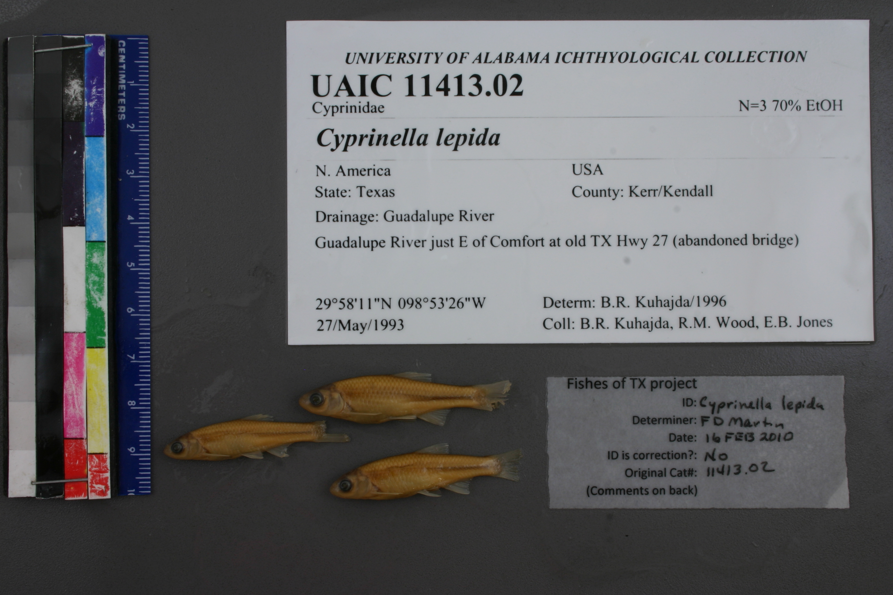
UAIC_11413.02
Not suspect, examinedPhotos
Map
Location
29.96508° N, 98.89734° W
(± 174.3
m)
Taxonomy
GenusCyprinella
Specieslepida
Specimen
Num Specimens0
Identification
DeterminerB.R. Kuhajda
Collection Event
CollectorB.R. Kuhajda, R.M.Wood, E.B. Jones
Collected Date1993.5.27
Geography
DrainageGuadalupe
CountryUnited States
StateTexas
LocalityGuadalupe River, just E of Comfort at old TX Hwy27 (abandoned bridge)
Record Source
Source
University of Alabama Ichthyology Collection
(type: specimens)
Institution
University of Alabama Ichthyology Collection
(type: museum)
Curator
Phillip Harris
Record Added
May 13, 2010
Record Last Modified
July 27, 2022
Data Processing Track
Track 2
From Data Set Received
04/2009 to 10/2010
Identification
Suspect Notes
None
Count
No data
Current Determination
Determiner
Unknown
Determination Date
July 26, 2022
Determination Type
taxonomic adjustment
Identification Comments
Geography-based change. We previously identified this as as C. lepida based on weak morphological evidence and the fact that other authors recognized C. lepida from the upper Guadalupe. FoTX (consensus meeting attendees) decided that there is not sufficient genetic support for determinations of C. lepida. in the upper Guadalupe.
Identification Confidence
Unknown
Previous Determination
Determiner
Floyd Douglas Martin
Determination Date
Feb. 16, 2010
Determination Type
specimen examination
Identification Comments
ID complete
Identification Confidence
High
Collecting Event
Collected
May 27, 1993
Collector(s)
Collecting Event ID
2624
Field Notes
There are no field notes available.
Locality
Region
Edwards Plateau
Jurisdiction
Kendall, Texas
Name
Guadalupe River at SH 27
Hydrography
Texas-Gulf Region
Central Texas Coastal
Guadalupe
Upper Guadalupe
Block Creek-Guadalupe River
Flat Rock Creek-Guadalupe River
Captive
no
Locality Photos
No locality photos available.
flag (suspect/examine)
suspect: noexamination: yes
taxonomy/determination note
call C. lepida, Adam will add determinations
date
date_range: 5/27/1993-5/27/1993
collectors
collectors: Kuhadja, Bernard R. Wood, R.M. Jones, E.B.
staff comment
ID Status: Specimen examined and ID'ed for FoTX project
Georef Remark: This could be one of 2 bridges right next to each other. Exact location unclear. Placed marker between the two and used an extent of 400 feet.
ID Confidence: high
collectors
collectors: Bernard R. Kuhadja, R.M. Wood, E.B. Jones
date
date_range: 5/27/1993-5/27/1993
georeference
Error: 174.291345600697
Remarks: This could be one of 2 bridges right next to each other. Exact location unclear. Placed marker between the two and used an extent of 400 feet.
Locality: Guadalupe River at SH 27Coordinates: 29.96507598;-98.897338244Georeferencer: GLMGeographic note: Inland USA TexasThis could be one of 2 bridges right next to each other. Exact location unclear. Placed marker between the two and used an extent of 400 feet.
Comments On UAIC_11413.02