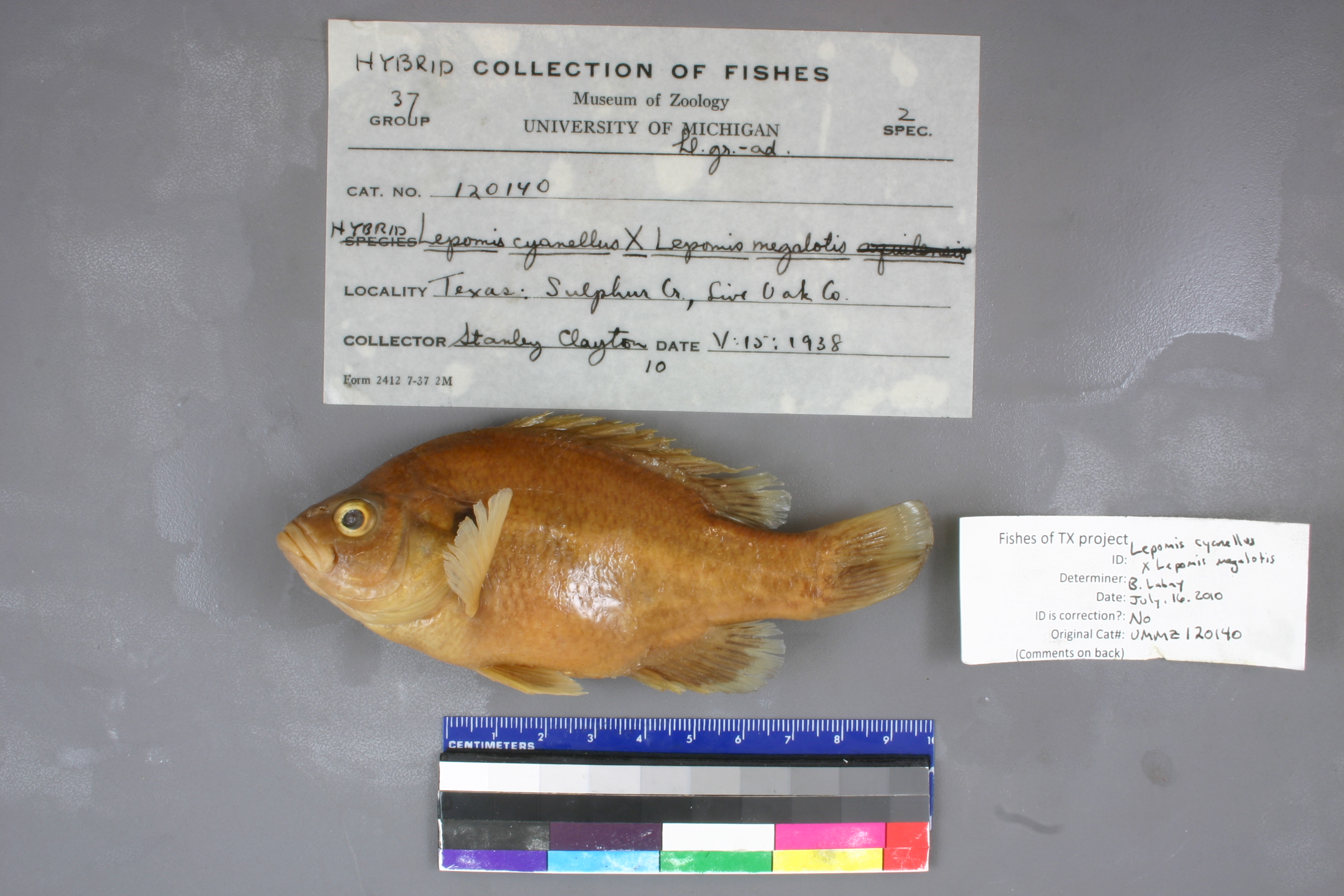
UMMZ_120140
Not suspect, examinedPhotos
Map
Location
28.45167° N, 98.10052° W
(± 562.3
m)
Taxonomy
GenusLepomis
Specieshybrid
Specimen
Num Specimens0
Identification
DeterminerHubbs
Collection Event
CollectorS Clayton
Collected Date1938.5.15
Geography
DrainageNueces
CountryUnited States
StateTexas
CountyLive Oak
LocalitySulphur Creek, trib of Nueces River, 0.25 mi E of Oakville, 6 mi E of Three Rivers
Record Source
Source
University of Michigan
(type: specimens)
Institution
University of Michigan
(type: university)
Curator
William L. Fink
Record Added
May 13, 2010
Record Last Modified
July 27, 2022
Data Processing Track
Track 2
From Data Set Received
04/2009 to 10/2010
Identification
Suspect Notes
None
Count
No data
Current Determination
Determiner
Unknown
Determination Date
July 11, 2022
Determination Type
taxonomic adjustment
Identification Comments
Determination found in FoTX database and determined to be the most recent determination. However, since the date of determination is not recorded in the database we hereby assign the date of our determination reconciliation effort, which makes it the most recent determination for this record.
Identification Confidence
Unknown
Previous Determination
Determiner
Ben Labay
Determination Date
July 16, 2010
Determination Type
specimen examination
Identification Comments
ID complete | anal fin count = 9; low confidence in ID; no evidence to confirm hybrid, but no reason to doubt ID
Identification Confidence
Low
Previous Determination
Determiner
Ben Labay
Determination Date
July 16, 2010
Determination Type
specimen examination
Identification Comments
ID complete | anal fin count = 9; low confidence in ID; no evidence to confirm hybrid, but no reason to doubt ID
Identification Confidence
Low
Collecting Event
Collected
May 15, 1938
Collector(s)
Collecting Event ID
7499
Field Notes
There are no field notes available.
Locality
Region
South Texas Brush Country
Jurisdiction
Live Oak, Texas
Name
Sulphur Creek east of Oakville
Hydrography
USGS HUC
Texas-Gulf Region
Nueces-Southwestern Texas Coastal
Nueces
Lower Nueces
Sulphur Creek-Nueces River
Lower Sulphur Creek
HydroBASINS
7519
751961
75196108
7519610801
751961080100
Captive
no
Locality Photos
No locality photos available.
flag (suspect/examine)
suspect: noexamination: yes
date
date_range: 5/15/1938-5/15/1938
collectors
collectors: Clayton, Stanley
collectors
collectors: Stanley Clayton
date
date_range: 5/15/1938-5/15/1938
staff comment
ID Status: Specimen examined and ID'ed for FoTX project
ID Comments: anal fin count = 9; low confidence in ID; no evidence to confirm hybrid, but no reason to doubt ID
Georef Remark: Reach runs between lines drawn northeast and southeast of Oakville geographic center.
ID Confidence: low
georeference
Error: 562.311194402249
Remarks: Reach runs between lines drawn northeast and southeast of Oakville geographic center.
Locality: Sulphur Creek east of OakvilleCoordinates: 28.451669216;-98.100524601Georeferencer: AECGeographic note: Inland USA TexasReach runs between lines drawn northeast and southeast of Oakville geographic center.
Comments On UMMZ_120140