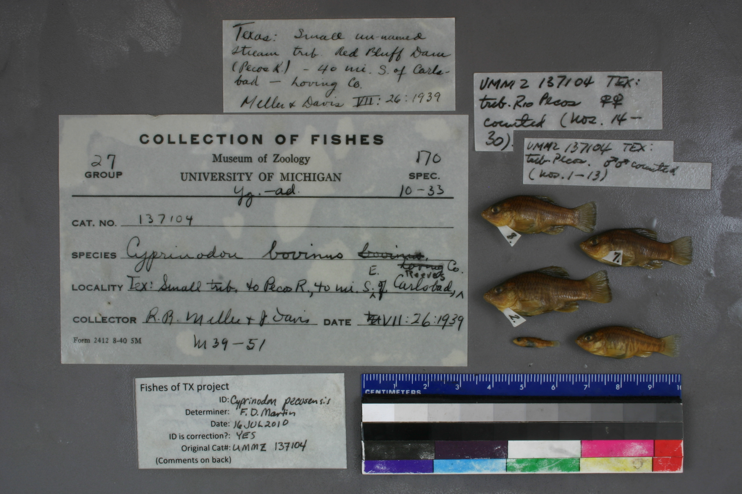
UMMZ_137104
Not suspect, examinedPhotos
Map
Location
31.95117° N, 103.94544° W
(± 6530.7
m)
Taxonomy
GenusCyprinodon
Speciesbovinus
Specimen
Num Specimens0
Identification
DeterminerHubbs
Collection Event
CollectorRR Miller & J Davis
Collected Date1939.7.26
Geography
DrainageRio Grande
CountryUnited States
StateTexas
CountyReeves
LocalitySmall trib. of Red Bluff Dam, Pecos River, 40 mi SE of Carlsbad (New Mexico)
Record Source
Source
University of Michigan
(type: specimens)
Institution
University of Michigan
(type: university)
Curator
William L. Fink
Record Added
May 13, 2010
Record Last Modified
July 27, 2022
Data Processing Track
Track 2
From Data Set Received
04/2009 to 10/2010
Identification
Suspect Notes
None
Count
No data
Current Determination
Determiner
Floyd Douglas Martin
Determination Date
July 16, 2010
Determination Type
specimen examination
Identification Comments
ID complete | belly in front of pelvics naked; depth of peduncle greater than distance from tip of snout to rear margin of eye
Identification Confidence
High
Collecting Event
Collected
July 26, 1939
Collector(s)
Collecting Event ID
7539
Field Notes
There are no field notes available.
Locality
Region
Trans Pecos
Jurisdiction
Reeves, Texas
Name
Pecos River watershed upstream of Red Bluff Dam
Hydrography
Rio Grande Region
Lower Pecos
Lower Pecos
Lower Pecos-Red Bluff Reservoir
Red Bluff Reservoir
Red Bluff Reservoir
Captive
no
Locality Photos
No locality photos available.
flag (suspect/examine)
suspect: noexamination: yes
date
date_range: 7/26/1939-7/26/1939
collectors
collectors: Miller, Robert Rush Davis, J.
collectors
collectors: Robert Rush Miller, J. Davis
date
date_range: 7/26/1939-7/26/1939
staff comment
ID Status: Specimen examined and ID'ed for FoTX project
ID Comments: belly in front of pelvics naked; depth of peduncle greater than distance from tip of snout to rear margin of eye
Georef Remark: Treated as shown and limited to Reeves County. If measured by air from Carlsbad New Mexico the point is outside the Pecos watershed.
ID Confidence: high
georeference
Error: 6530.71795197198
Remarks: Treated as shown and limited to Reeves County. If measured by air from Carlsbad New Mexico the point is outside the Pecos watershed.
Locality: Pecos River watershed upstream of Red Bluff DamCoordinates: 31.951170624;-103.945442756Georeferencer: AECGeographic note: Inland USA TexasTreated as shown and limited to Reeves County. If measured by air from Carlsbad New Mexico the point is outside the Pecos watershed.
Comments On UMMZ_137104