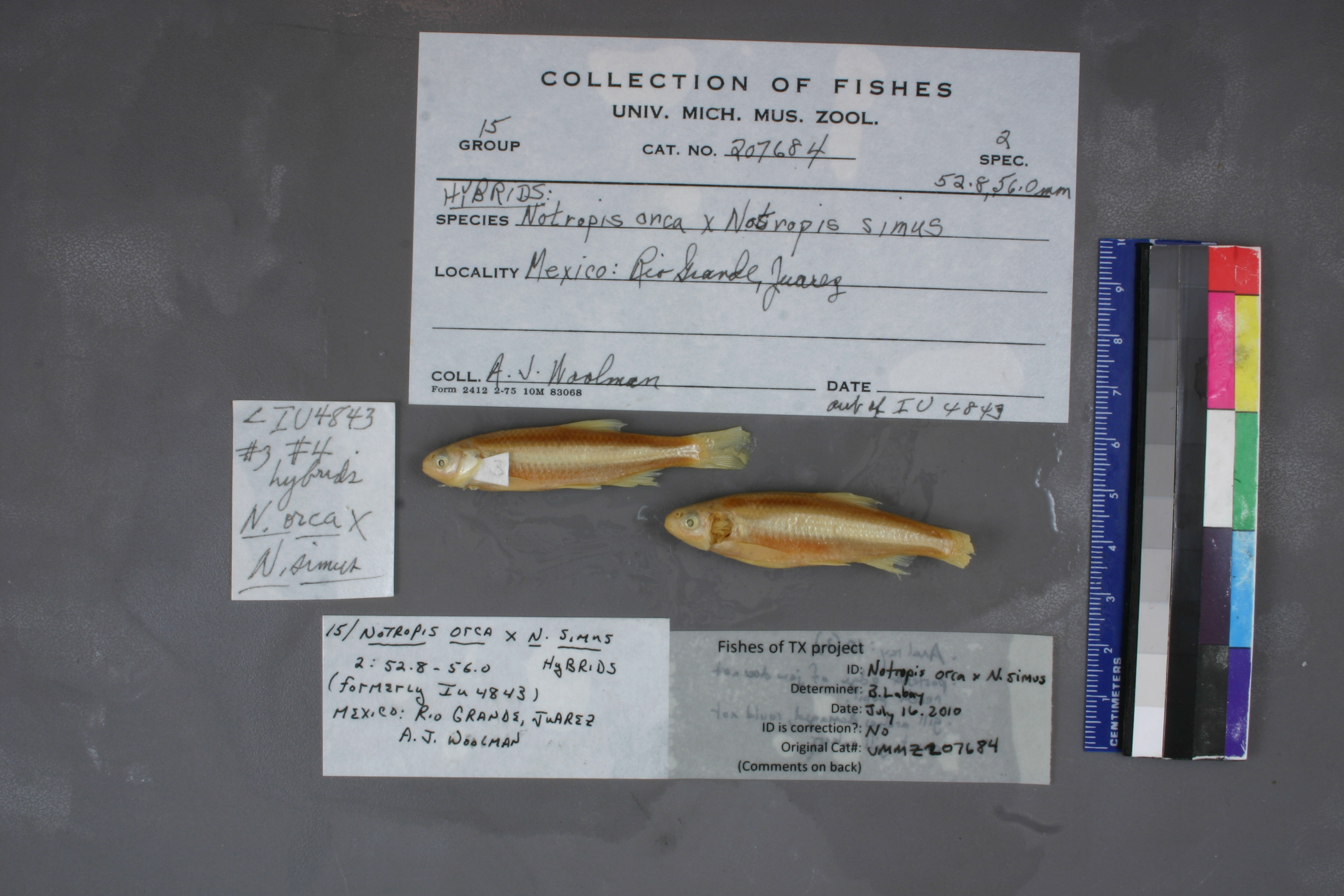
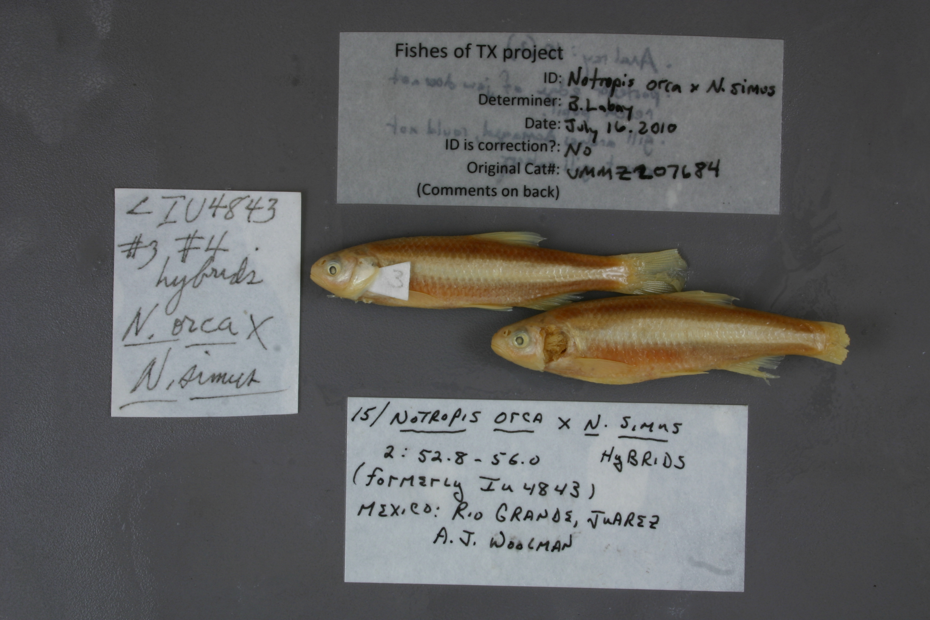
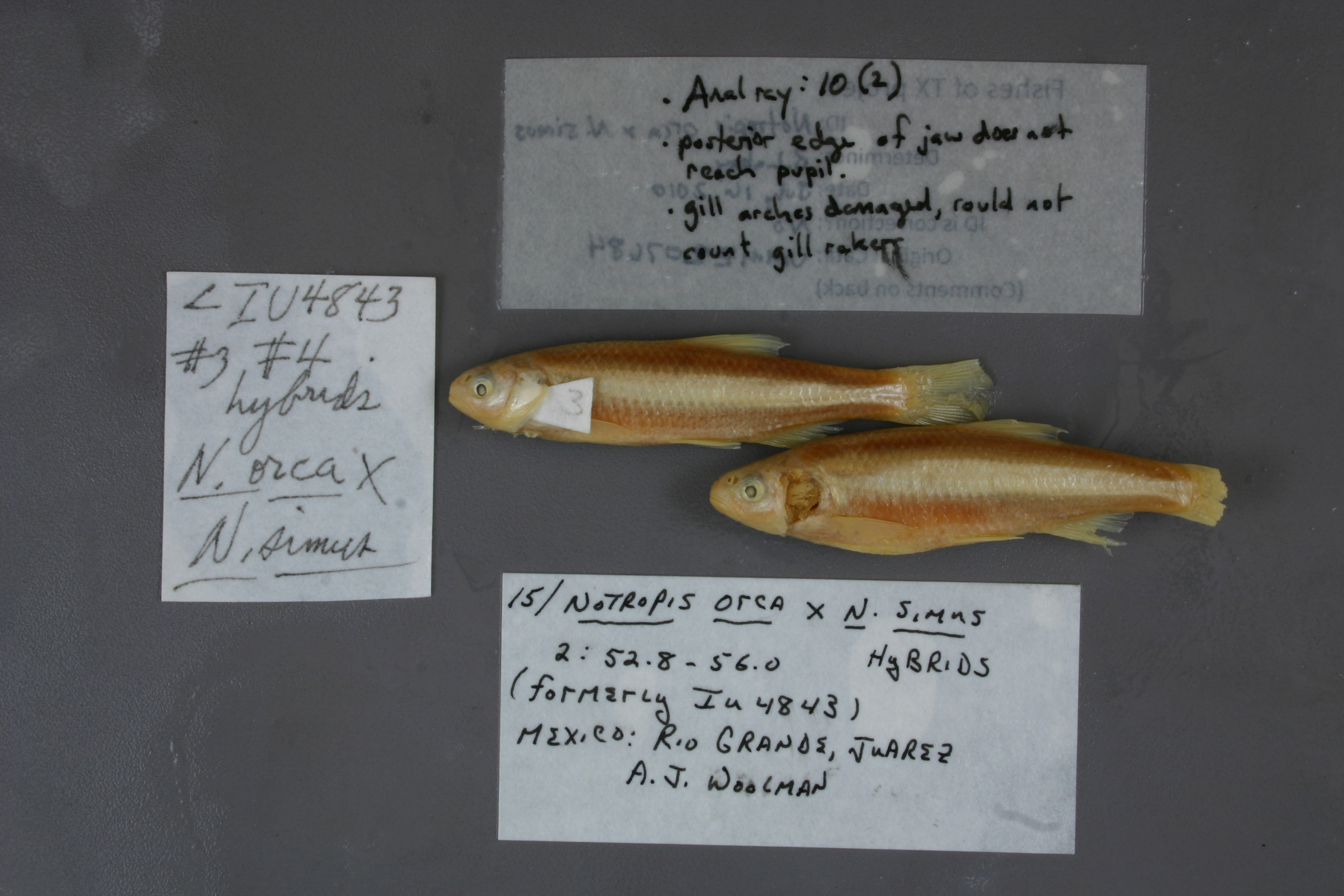
UMMZ_207684
Suspect, pending examinationPhotos
Map
Location
31.75227° N, 106.49504° W
(± 4700
m)
Taxonomy
GenusNotropis
Specieshybrid
Specimen
Num Specimens0
Identification
DeterminerRR Miller & B Chernoff
Collection Event
CollectorAJ Woolman
Collected Datenone
Geography
CountryMexico
StateChihuahua
CountyUnknown
LocalityRio Grande, Juarez
Record Source
Source
University of Michigan
(type: specimens)
Institution
University of Michigan
(type: university)
Curator
William L. Fink
Record Added
May 13, 2010
Record Last Modified
July 27, 2022
Data Processing Track
Track 2
From Data Set Received
04/2009 to 10/2010
Identification
Suspect Notes
added as bulk process; species not known from study area
Count
No data
Current Determination
Determiner
Ben Labay
Determination Date
July 16, 2010
Determination Type
specimen examination
Identification Comments
ID complete | anal ray count 10(2); posterior edge of jaw does not reach pupil; gill arches damaged, could not count gill rakers; hybrid
Identification Confidence
High
Collecting Event
Collected
Jan. 1, 1891
– Dec. 31, 1891
Collector(s)
Collecting Event ID
7504
Field Notes
There are no field notes available.
Locality
Region
Trans Pecos
Jurisdiction
El Paso, Texas
Name
Rio Grande at El Paso
Hydrography
Rio Grande Region
Rio Grande-Amistad
Rio Grande-Fort Quitman
Rio Grande-Fort Quitman
Bowman Lateral-Rio Grande
Ascarate Lake-Rio Grande
Captive
no
Locality Photos
No locality photos available.
HUC 12
130401000107
Georeferencing Remarks
Woolman's report (https://www.biodiversitylibrary.org/item/215790#page/73/mode/1up) indicates that he collected on the Rio Grande at the water works in El Paso. Can't find location of historic water pump station, but point placed on river at current water treatment plant, which falls inthe the historical geography of El Paso, based on a 1908 map (http://legacy.lib.utexas.edu/maps/historical/el_paso08.jpg). Extent runs to edge of town as indicated on the map.
Georeferencing Annotation
—
Has not been Georeferenced because
—
flag (suspect/examine)
note: Suspect record remains to be resolved after an initial examination. This record has become somewhat of a research project. Comments that could help resolve the locality or determination are solicited.
Examination: Pending
flag (suspect/examine)
suspect: noexamination: yes
georeference
Error: 4700
Remarks: Woolman's report (https://www.biodiversitylibrary.org/item/215790#page/73/mode/1up) indicates that he collected on the Rio Grande at the water works in El Paso. Can't find location of historic water pump station, but point placed on river at current water treatment plant, which falls inthe the historical geography of El Paso, based on a 1908 map (http://legacy.lib.utexas.edu/maps/historical/el_paso08.jpg). Extent runs to edge of town as indicated on the map.
Locality: Rio Grande at El PasoCoordinates: -106.495044, 31.752268Georeferencer: Adam CohenWoolman's report (https://www.biodiversitylibrary.org/item/215790#page/73/mode/1up) indicates that he collected on the Rio Grande at the water works in El Paso. Can't find location of historic water pump station, but point placed on river at current water treatment plant, which falls inthe the historical geography of El Paso, based on a 1908 map (http://legacy.lib.utexas.edu/maps/historical/el_paso08.jpg). Extent runs to edge of town as indicated on the map.
date
date_range: 1/1/1891-12/31/1891
collectors
collectors: Woolman, Albert J.
staff comment
ID Status: Specimen examined and ID'ed for FoTX project
ID Comments: anal ray count 10(2); posterior edge of jaw does not reach pupil; gill arches damaged, could not count gill rakers; hybrid
ID Confidence: high
collectors
collectors: Albert J. Woolman
date
date_range: 1/1/1891-12/31/1891
georeference
Error: 7254.92275196887Locality: Rio Grande River at Ciudad JuarezCoordinates: 31.759398122;-106.44265462Georeferencer: AECGeographic note: Inland USA Texas
Comments On UMMZ_207684