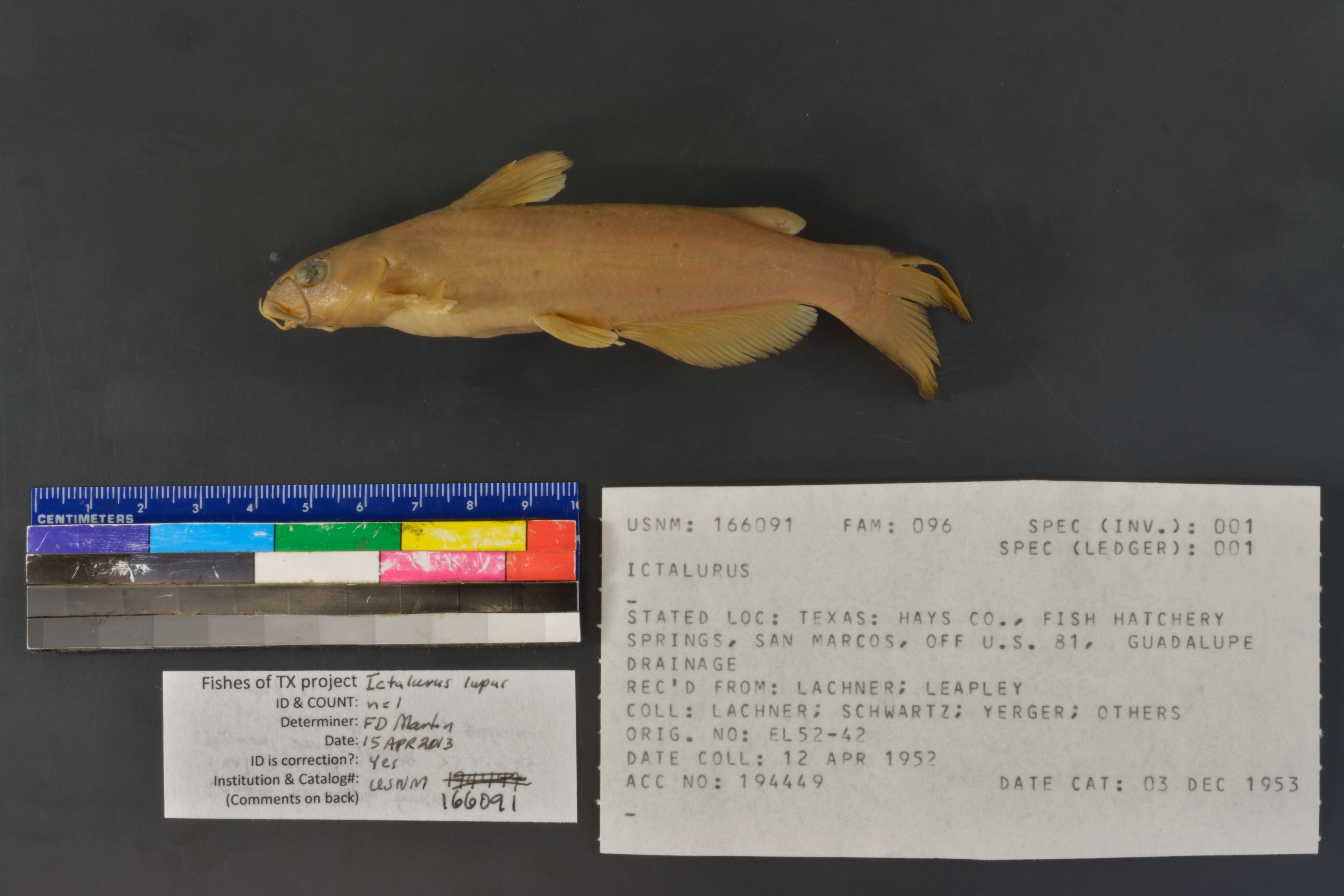
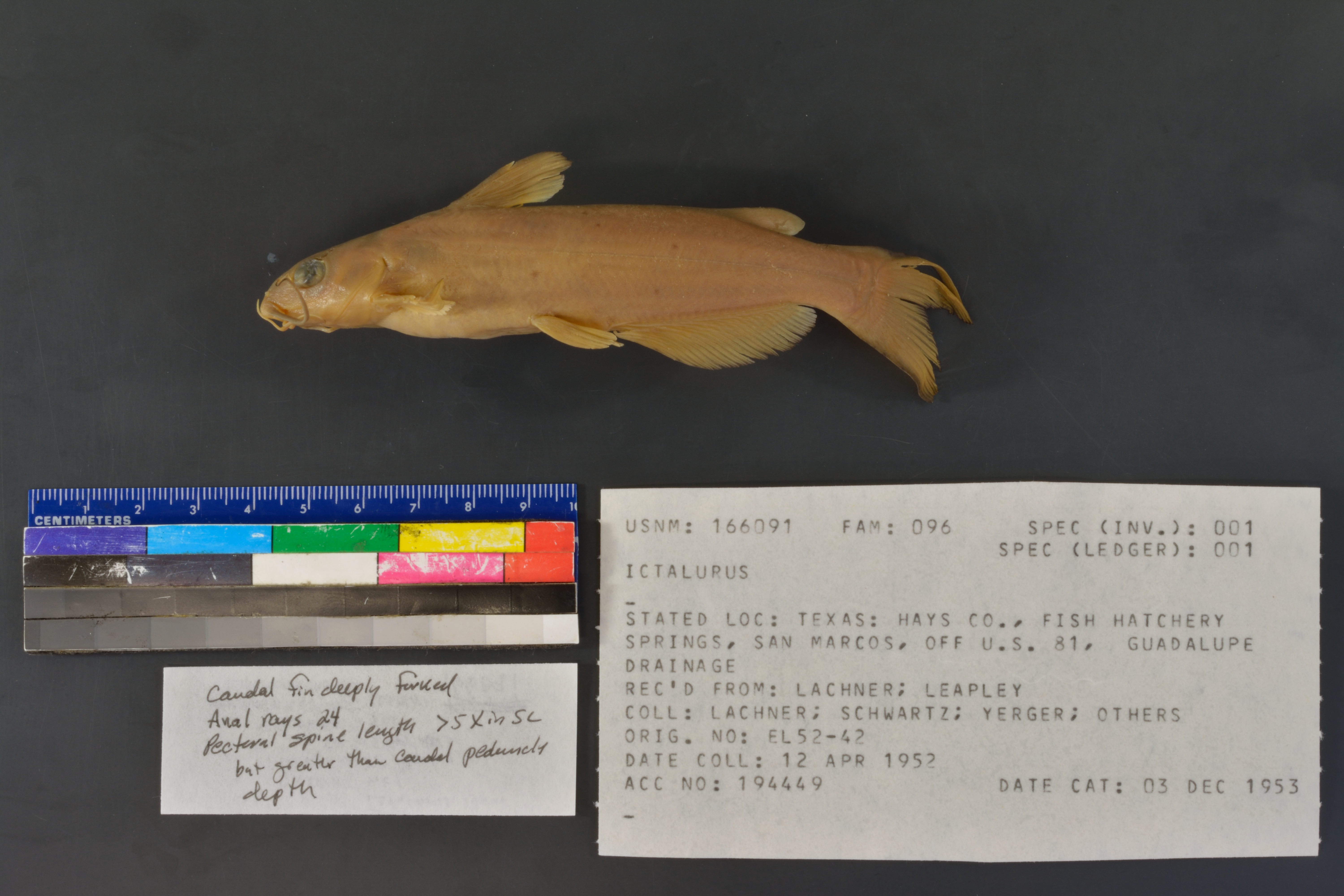
USNM_166091
Not suspect, examinedPhotos
Map
Location
29.88958° N, 97.93647° W
(± 400
m)
Taxonomy
GenusIctalurus
Collection Event
CollectorLachner et al.
Collected Date1952 Apr 12 - 0000 00 00
Geography
CountryUnited States
StateTexas
CountyHays
LocalityTexas: Hays Co., Fish Hatchery Springs, San Marcos, Off U.S. 81, Guadalupe Drainage
Record Source
Source
National Museum of Natural History
(type: specimens)
Institution
National Museum of Natural History
(type: museum)
Curator
Lynne Parenti
Record Added
May 13, 2010
Record Last Modified
June 22, 2022
Data Processing Track
Track 2
From Data Set Received
04/2009 to 10/2010
Identification
Suspect Notes
None
Count
No data
Current Determination
Determiner
Floyd Douglas Martin
Determination Date
April 15, 2013
Determination Type
specimen examination
Identification Comments
Specimen examined and Id'ed for FoTX project. | caudal fin deeply forked; anal rays 24; pectoral spine length >5x in SL but greater than caudal peduncle depth
Identification Confidence
High
Collecting Event
Collected
April 12, 1952
Collector(s)
Collecting Event ID
30544
Field Notes
There are no field notes available.
Locality
Jurisdiction
Hays, Texas
Name
Spring feeding Federal Fish Hatchery
Hydrography
Texas-Gulf Region
Central Texas Coastal
Guadalupe
San Marcos
Upper San Marcos River
Purgatory Creek-San Marcos River
Captive
yes
Locality Photos
No locality photos available.
HUC 12
121002030302
Georeferencing Remarks
Point placed on Weismuller Spring (as identified by Google Maps) and extent covers what remains of hatchery ponds as best determined from Google images.
Georeferencing Annotation
Found record to be captive, as per note from Adam Cohen. Removed coordinates and updated record as nogeoreference, captive.
Has not been Georeferenced because
—
georeference
Error: 400
Remarks: Point placed on Weismuller Spring (as identified by Google Maps) and extent covers what remains of hatchery ponds as best determined from Google images.
Locality: Spring feeding Federal Fish HatcheryCoordinates: -97.936474, 29.889575Georeferencer: Adam CohenPoint placed on Weismuller Spring (as identified by Google Maps) and extent covers what remains of hatchery ponds as best determined from Google images.
flag (suspect/examine)
suspect: noexamination: yes
captive
determined to be captive
staff comment
not available or not found
date
date_range: 4/12/1952-4/12/1952
collectors
collectors: Lachner, Ernest A.
collectors
collectors: Ernest A. Lachner
date
date_range: 4/12/1952-4/12/1952
staff comment
ID Status: This lot in need of examination, but we have not been able to find this specimen at the donor institution. Specimen is likely either on loan, mis-shelved, permanently lost or in rare cases destroyed. Work in progress.
Georef Annotation: Found record to be captive, as per note from Adam Cohen. Removed coordinates and updated record as nogeoreference, captive.
Not Georeferenced Because: Captive
georeference
Remarks: Found record to be captive, as per note from Adam Cohen. Removed coordinates and updated record as nogeoreference, captive.
Coordinates: ;Georeferencer: MJCGeographic note: Inland USA TexasFound record to be captive, as per note from Adam Cohen. Removed coordinates and updated record as nogeoreference, captive.
staff comment
not available or not found
Comments On USNM_166091